Honeywell's Popular Handheld Now Available For Helicopters | Aero-News Network
Aero-News Network
RSS icon RSS feed
podcast icon MP3 podcast
Subscribe Aero-News e-mail Newsletter Subscribe

Airborne Unlimited -- Most Recent Daily Episodes

Episode Date

Airborne-Monday

Airborne-Tuesday

Airborne-Wednesday Airborne-Thursday

Airborne-Friday

Airborne On YouTube

Airborne-Unlimited-04.29.24

Airborne-Unlimited-04.23.24

Airborne-Unlimited-04.24.24 Airborne-FltTraining-04.25.24

Airborne-Unlimited-04.26.24

Tue, Feb 23, 2010

Honeywell's Popular Handheld Now Available For Helicopters

Bendix/King By Honeywell AV8OR Provides Portable Weather, Traffic and GPS

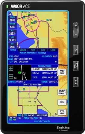
Honeywell announced Sunday at Heli-Expo 2010 that the AV8OR handheld Global Positioning System (GPS) is now available for helicopter operators.

"The AV8OR is a terrific addition to any helicopter, providing situational awareness of weather, terrain, traffic and airspace for very little cost," said Chad Cundiff, vice president, Crew Interface and Displays, Honeywell Aerospace. "For about $800, helicopter pilots get moving-map navigation with terrain awareness, which they can use on the ground or in the air, making every trip simple from door -- to air -- to door. The unit can also wirelessly interface to traffic and weather information."

The AV8OR is a portable touch-screen GPS for use in the car or in the air, with real-time weather capability, moving-map navigation and video-in capability. Its large 4.3-inch screen can display weather, from Honeywell's KDR 610 or the WxWorx portable receiver, and traffic from Zaon Flight Systems' XRX portable traffic receiver. The moving map display incorporates helicopter symbology, low altitude helicopter routes, helipads and controlled airspace.

The navigation database includes terrain shading and a SmartProfile view, enabling operators to see the terrain in the flight path of the helicopter.

With a $99 a year subscription, AV8OR offer daily updates on fuel pricing through Flight Guide, as well as on-field services, restaurants, taxi services and hotels. A dedicated online customer center provides operators with simple software updating capability.

The AV8OR is the first touch-screen handheld device developed for both aviation and automotive use, the first airway planner, the first to have multimedia capability and the first to have a Bluetooth phone interface -- all in one device.

FMI: www.honeywell.com

Advertisement

More News

Unfortunate... ANN/SportPlane Resource Guide Adds To Cautionary Advisories

The Industry Continues to be Rocked By Some Questionable Operations Recent investigations and a great deal of data has resulted in ANN’s SportPlane Resource Guide’s rep>[...]

ANN FAQ: Turn On Post Notifications

Make Sure You NEVER Miss A New Story From Aero-News Network Do you ever feel like you never see posts from a certain person or page on Facebook or Instagram? Here’s how you c>[...]

ANN's Daily Aero-Term (04.29.24): Visual Approach Slope Indicator (VASI)

Visual Approach Slope Indicator (VASI) An airport lighting facility providing vertical visual approach slope guidance to aircraft during approach to landing by radiating a directio>[...]

ANN's Daily Aero-Term (04.28.24): Airport Marking Aids

Airport Marking Aids Markings used on runway and taxiway surfaces to identify a specific runway, a runway threshold, a centerline, a hold line, etc. A runway should be marked in ac>[...]

ANN's Daily Aero-Linx (04.28.24)

Aero Linx: The Skyhawk Association The Skyhawk Association is a non-profit organization founded by former Skyhawk Pilots which is open to anyone with an affinity for the A-4 Skyhaw>[...]

blog comments powered by Disqus


Advertisement

Advertisement

Podcasts

Advertisement

© 2007 - 2024 Web Development & Design by Pauli Systems, LC