Unlocking Space Data: SBIRS To Supply Infrared Data For Developers | Aero-News Network
Aero-News Network
RSS icon RSS feed
podcast icon MP3 podcast
Subscribe Aero-News e-mail Newsletter Subscribe

Airborne Unlimited -- Most Recent Daily Episodes

Episode Date

Airborne-Monday

Airborne-Tuesday

Airborne-Wednesday Airborne-Thursday

Airborne-Friday

Airborne On YouTube

Airborne-Unlimited-04.29.24

Airborne-Unlimited-04.23.24

Airborne-Unlimited-04.24.24 Airborne-FltTraining-04.25.24

Airborne-Unlimited-04.26.24

Mon, Jul 11, 2016

Unlocking Space Data: SBIRS To Supply Infrared Data For Developers

A New Air Force Laboratory Invites Developers To Examine How Data From SBIRS Can Be Better Applied On And Off The Battlefield

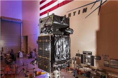
For the first time, infrared data from the Lockheed Martin-built Space Based Infrared System (SBIRS) will be made available for new military and civilian uses at the Air Force's recently opened data utilization lab in Boulder, Colorado.

While SBIRS' primary mission is strategic missile warning, the system can support a wide range of research and development projects across the field of remote sensing, which is the monitoring, observing and gathering of information on the Earth and atmosphere from space.

"SBIRS uses powerful overhead sensors that collect and transmit significant amounts of infrared data," said David Sheridan, vice president of Lockheed Martin's Overhead Persistent Infrared (OPIR) systems mission area. "By giving researchers access to this data, our objective is for them to find new, innovative uses for improving situational awareness—whether it is for tactical military missions, natural disasters or even firefighting."

In the past year, the Air Force has seen a growing demand from the military, intelligence and civil communities, as well as academia, for remote sensing capabilities. For areas like battlespace awareness, intelligence and 24/7 tactical alerts, promising solutions developed in the lab will be considered for operational applications at the SBIRS Mission Control Station, OPIR Battlespace Awareness Center at Buckley Air Force Base, Colorado.

"In an effort to develop, test and transition new or enhanced capabilities, the data utilization lab will provide an opportunity for users, data consumers and third-party developers to access these sensor feeds—providing an open framework architecture to host new tools, algorithms and processing solutions," said Lt. Colonel Ross Johnston of the Air Force Space and Missile Systems Center.

Along with government and industry teams, academic organizations like the University of Colorado will use the data provided by the lab to facilitate collaboration and support research in areas that include monitoring the Earth's surface to determine the potential for forest fires or informing critical decisions during active fires.

"The benefit of having public-private partnerships is that we can bring together different stakeholders, in addition to doing research, and understand how we can use data from space assets to solve societal issues," said Scott Palo, associate dean for research at the University of Colorado's College of Engineering and Applied Science. "We can also provide opportunities for students, as well as small and medium-sized businesses, to connect with industry and government and develop a broader vision that we can all build upon."

(Source: Lockheed Martin news release. Image provided by Lockheed Martin)

FMI: www.lockheedmartin.com/sbirs

Advertisement

More News

Unfortunate... ANN/SportPlane Resource Guide Adds To Cautionary Advisories

The Industry Continues to be Rocked By Some Questionable Operations Recent investigations and a great deal of data has resulted in ANN’s SportPlane Resource Guide’s rep>[...]

ANN FAQ: Turn On Post Notifications

Make Sure You NEVER Miss A New Story From Aero-News Network Do you ever feel like you never see posts from a certain person or page on Facebook or Instagram? Here’s how you c>[...]

ANN's Daily Aero-Term (04.29.24): Visual Approach Slope Indicator (VASI)

Visual Approach Slope Indicator (VASI) An airport lighting facility providing vertical visual approach slope guidance to aircraft during approach to landing by radiating a directio>[...]

ANN's Daily Aero-Term (04.28.24): Airport Marking Aids

Airport Marking Aids Markings used on runway and taxiway surfaces to identify a specific runway, a runway threshold, a centerline, a hold line, etc. A runway should be marked in ac>[...]

ANN's Daily Aero-Linx (04.28.24)

Aero Linx: The Skyhawk Association The Skyhawk Association is a non-profit organization founded by former Skyhawk Pilots which is open to anyone with an affinity for the A-4 Skyhaw>[...]

blog comments powered by Disqus


Advertisement

Advertisement

Podcasts

Advertisement

© 2007 - 2024 Web Development & Design by Pauli Systems, LC