Mon, Jul 23, 2012
ISERV Pathfinder To Be Installed In The Station's Destiny Laboratory
A remote-controlled Earth-observing camera system called ISERV launched to the International Space Station (ISS) aboard the Japan Aerospace Exploration Agency's third H-II Transfer Vehicle (HTV-3) Friday. Once installed, the system will be directed by researchers on the ground to acquire imagery of specific areas of the globe for disaster analysis and environmental studies.
ISERV stands for the International Space Station SERVIR Environmental Research and Visualization System. The space station provides researchers a unique perspective through global observations from space. SERVIR is a Spanish acronym meaning "to serve." Also known as the Regional Visualization and Monitoring System, the program provides satellite data and tools to environmental decision makers in developing countries. SERVIR is a partnership between NASA and the U.S. Agency for International Development (USAID).
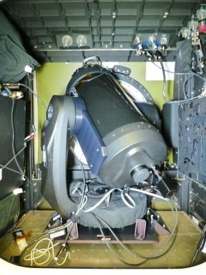
ISERV will be installed in the Window Observational Research Facility (WORF) in the station's Destiny laboratory. The system is intended to help scientists gain operational experience and expertise and inform the design of a more capable system in the future. Ideally, a future operational system will be able to monitor disasters on Earth. "ISERV came about because officials in developing countries are sometimes unable to acquire the images they need to address environmental threats and provide post-disaster assessments," said Nancy Searby, capacity building program manager for the SERVIR program at NASA Headquarters in Washington. "The SERVIR team approached NASA's ISS and Earth Science Applied Sciences Program with the concept of acquiring the needed imagery from the ISS. The ISERV test bed payload is a result of that collaboration."
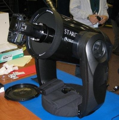
The ISERV system, based on a modified commercial telescope and driven by custom software, will use the Earth-facing Destiny science window to obtain images of Earth's surface. It will then transmit the data to scientists on the ground. "Images captured from ISERV on the ISS could provide valuable information back here on Earth," said Dan Irwin, SERVIR program director at Marshall. "We hope it will provide new data and information from space related to natural disasters, environmental crises and the increased effects of climate variability on human populations."
ISERV is the first of an envisioned series of space station Earth-observing instruments, each to feature progressively more capable sensors. Future sensors could be mounted on the exterior of the station for a clearer, wider view of Earth. ISERV development was funded as a collaboration between NASA's Human Exploration and Operations Directorate and the Science Mission Directorate's Earth Science Division Applied Sciences Program.
The team at the Payload Operations Center at Marshall is creating computer-based materials for training the space station crew to assemble and install ISERV in the WORF rack. Normal operations aboard station are set to begin in November.
(Images provided by NASA)
More News
Hold Procedure A predetermined maneuver which keeps aircraft within a specified airspace while awaiting further clearance from air traffic control. Also used during ground operatio>[...]
Altitude Readout An aircraft’s altitude, transmitted via the Mode C transponder feature, that is visually displayed in 100-foot increments on a radar scope having readout cap>[...]
Aero Linx: European Hang Gliding and Paragliding Union (EHPU) The general aim of the EHPU is to promote and protect hang gliding and paragliding in Europe. In order to achieve this>[...]
Also: Skydio Chief, Uncle Sam Sues, Dash 7 magniX, OR UAS Accelerator US Secretary of the Air Force Frank Kendall was given a turn around the patch in the 'X-62A Variable In-flight>[...]
"The need for innovation at speed and scale is greater than ever. The X-62A VISTA is a crucial platform in our efforts to develop, test and integrate AI, as well as to establish AI>[...]
 ANN's Daily Aero-Term (05.09.24): Hold Procedure

