Wed, Mar 30, 2011
Navigation and XM Weather Integration Also Included
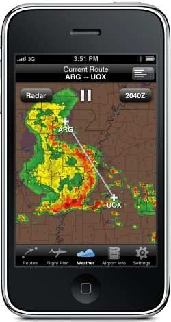
Garmin subsidiary Digital Cyclone has updated its Garmin Pilot
My-Cast application for Apple iOS-based devices that offers
geo-referenced approach charts, secondary navigational capability
and optional integration with XM WX Weather. Garmin Pilot My-Cast
is a premium aviation weather, flight planning, flight filing and
navigation application exclusively for customers in the U.S. and
Canada.

“The use of smart devices in the cockpit is becoming more
and more ubiquitous,” said Craig Burfeind, president of
Digital Cyclone Tuesday. “The added functionality of the new
Pilot My- Cast increases the number of ways in which pilots can use
these devices throughout the entire flight experience.”
The newest version of Pilot My-Cast features geo-referenced
FliteCharts and airport taxi diagrams, bringing pilots a new level
of situational awareness. This latest version also can utilize the
iPad’s internal GPS receiver (or external GPS receiver, sold
separately) as a means of secondary navigation. The new app also
lets users connect to XM WX Satellite Weather wirelessly through
the Baron Mobile Link paired with a Satellite Weather receiver
(sold separately, subscription required) to receive highly-detailed
weather forecasts and current conditions, including high resolution
NEXRAD radar, lightning, METARs and winds aloft. Best of all,
unlike the limitations of conventional cellular transmissions,
pilots can continually view the latest weather reports while at
altitude.
Similar to Pilot My-Cast’s existing iOS version, the new
app includes functions that let pilots easily create routes and
file a flight plan, view weather conditions and forecasts over
their phone’s wireless network, and access the AOPA Airport
Directory. A Pilot My-Cast application is being developed for
Android devices as well and is expected to be available in
June.
The new version of Garmin Pilot My-Cast for iOS is expected to
be available in the app store in mid-April as a free download for
the first 30 days. After that, users can pay a monthly fee of $9.99
or an annual subscription of $99.99 for the base package including
navigation and XM WX Satellite Weather integration. Geo-referenced
FliteCharts will be available for an additional $49.99
annually.
More News
Say Altitude Used by ATC to ascertain an aircraft's specific altitude/flight level. When the aircraft is climbing or descending, the pilot should state the indicated altitude round>[...]
Aero Linx: European Air Law Association (EALA) EALA was established in 1988 with the aim to promote the study of European air law and to provide an open forum for those with an int>[...]
From 2023 (YouTube Version): The Life, Death, Life, Death, and Life of a Glorious Warbird In 1981, business-owner Jim Tobul and his father purchased a Chance-Vought F4U Corsair. Mo>[...]
Also: USCG Retires MH-65 Dolphins, Irish Aviation Authority, NATCA Warns FAA, Diamond DA42 AD This summer, history enthusiasts will have a unique opportunity to experience World Wa>[...]
Also: WACO Kitchen Bails, French SportPlane Mfr to FL, Dynon-Advance Flight Systems, Innovation Preview Bobby Bailey, a bit of a fixture in sport aviation circles for his work with>[...]
 ANN's Daily Aero-Term (05.01.24): Say Altitude

