Drones Map A Major Canadian City For The First Time | Aero-News Network
Aero-News Network
RSS icon RSS feed
podcast icon MP3 podcast
Subscribe Aero-News e-mail Newsletter Subscribe

Airborne Unlimited -- Most Recent Daily Episodes

Episode Date

Airborne-Monday

Airborne-Tuesday

Airborne-Wednesday Airborne-Thursday

Airborne-Friday

Airborne On YouTube

Airborne-Unlimited-05.06.24

Airborne-NextGen-04.30.24

Airborne-Unlimited-05.01.24 Airborne-AffordableFlyers--05.02.24

Airborne-Unlimited-05.03.24

Fri, Jul 13, 2018

Drones Map A Major Canadian City For The First Time

Global UAV And InDro Robotics Conduct First Sanctioned UAV Mapping Missions

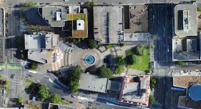
Global UAV Technologies, together with InDro Robotics Inc. (“InDro”), a compliant UAV mapping, training, and consulting business, and High Eye Aerial Imaging Inc. (“High Eye”), have concluded the first UAV mapping mission over a major Canadian metropolitan city. The first of its kind operation, flown over the downtown core of Victoria, B.C. on June 14th, 2018, was completed for the City of Victoria’s Emergency Management Division and conducted alongside members of Transport Canada.

Two flights were completed covering a 0.57 square mile area with approximately 1000 high resolution drone acquired images collected. The survey was completed in one day by a professional flight crew which included personnel from InDro Robotics, Global UAV Technologies Ltd., and High Eye Aerial Imaging Inc. The flight was conducted with a Sensefly eBee plus RTK/PPK UAV.

“This first of its kind operation signals a significant achievement for High Eye, InDro and Global UAV. The ability to safely operate a UAV over a populated downtown core without interrupting people’s daily commute is a milestone event and will aid in progressing UAV regulations in Canada. The successful collaboration between Global UAV, InDro Robotics, Transport Canada and the City of Victoria on the project provides a foundation for future collaborations on similar missions.” said Jeremy McCalla, Global UAV Technologies’ Business Development and Operations Manager.

“Transport Canada’s willingness to work with the team to ensure this mission, vital to emergency planning and preparedness, could be flown in an efficient and safe manner has provided not only a wealth of data for emergency response but also a new depth of knowledge for future operations in such environments.” stated Phillip Reece, CEO of InDro Robotics.

(Image provided with Global UAV news release)

FMI: www.globaluavtech.com

Advertisement

More News

ANN's Daily Aero-Term (05.09.24): Hold Procedure

Hold Procedure A predetermined maneuver which keeps aircraft within a specified airspace while awaiting further clearance from air traffic control. Also used during ground operatio>[...]

ANN's Daily Aero-Term (05.06.24): Altitude Readout

Altitude Readout An aircraft’s altitude, transmitted via the Mode C transponder feature, that is visually displayed in 100-foot increments on a radar scope having readout cap>[...]

ANN's Daily Aero-Linx (05.06.24)

Aero Linx: European Hang Gliding and Paragliding Union (EHPU) The general aim of the EHPU is to promote and protect hang gliding and paragliding in Europe. In order to achieve this>[...]

Airborne-NextGen 05.07.24: AI-Piloted F-16, AgEagle, 1st 2 WorldView Sats

Also: Skydio Chief, Uncle Sam Sues, Dash 7 magniX, OR UAS Accelerator US Secretary of the Air Force Frank Kendall was given a turn around the patch in the 'X-62A Variable In-flight>[...]

Aero-News: Quote of the Day (05.07.24)

"The need for innovation at speed and scale is greater than ever. The X-62A VISTA is a crucial platform in our efforts to develop, test and integrate AI, as well as to establish AI>[...]

blog comments powered by Disqus


Advertisement

Advertisement

Podcasts

Advertisement

© 2007 - 2024 Web Development & Design by Pauli Systems, LC