KY TFR: 10.16.06 | Aero-News Network
Aero-News Network
RSS icon RSS feed
podcast icon MP3 podcast
Subscribe Aero-News e-mail Newsletter Subscribe

Airborne Unlimited -- Most Recent Daily Episodes

Episode Date

Airborne-Monday

Airborne-Tuesday

Airborne-Wednesday Airborne-Thursday

Airborne-Friday

Airborne On YouTube

Airborne-Unlimited-04.29.24

Airborne-Unlimited-04.23.24

Airborne-Unlimited-04.24.24 Airborne-FltTraining-04.25.24

Airborne-Unlimited-04.26.24

Fri, Oct 13, 2006

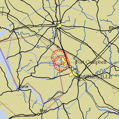
KY TFR: 10.16.06

NOTAM Number: FDC 6/3466
Issue Date: October 13, 2006 at 17:57 UTC
Location: Fort Campbell, Kentucky
Beginning Date and Time: October 16, 2006 at 19:05 UTC
Ending Date and Time: October 16, 2006 at 21:10 UTC
Reason for NOTAM: Temporary flight restrictions for VIP (Very Important Person) Movement
Type: VIP
Replaced NOTAM(s): N/A

Affected Area(s)

Area A
 Airspace Definition:
 TFR Center: 4.7 nautical miles from CLARKSVILLE VOR/DME(CKV) on the 308 radial (Latitude: 36º40'06"N, Longitude: 87º29'24"W)
 Radius: 3 nautical miles
 Altitude: From the surface up to but not including 3000 feet AGL
 Effective Date(s):
 October 16, 2006 at 19:05 UTC (October 16, 2006 at 14:05 EST) - October 16, 2006 at 19:55 UTC (October 16, 2006 at 14:55 EST)

Area B
 Airspace Definition:
 TFR Center: 3.2 nautical miles from CLARKSVILLE VOR/DME(CKV) on the 280 radial (Latitude: 36º37'48"N, Longitude: 87º28'38"W)
 Radius: 3 nautical miles
 Altitude: From the surface up to but not including 3000 feet AGL
 Effective Date(s):
 October 16, 2006 at 19:20 UTC (October 16, 2006 at 14:20 EST) - October 16, 2006 at 20:55 UTC (October 16, 2006 at 15:55 EST)

Area C
 Airspace Definition:
 TFR Center: 4.7 nautical miles from CLARKSVILLE VOR/DME(CKV) on the 308 radial (Latitude: 36º40'06"N, Longitude: 87º29'24"W)
 Radius: 3 nautical miles
 Altitude: From the surface up to but not including 3000 feet AGL
 Effective Date(s):
 October 16, 2006 at 20:20 UTC (October 16, 2006 at 15:20 EST) - October 16, 2006 at 21:10 UTC (October 16, 2006 at 16:10 EST)

Operating Restrictions and Requirements

No pilots may operate an aircraft in the areas covered by this NOTAM (except as described).

 Unless otherwise authorized by ATC.

Other Information:

ARTCC: ZME - Memphis Center
Authority: Title 14 CFR section 91.141

FMI: www.tfr.faa.gov, Depicted TFR data may not be a complete listing. Pilots should not use the information on this website for flight planning purposes. For the latest information, call your local Flight Service Station at 1-800-WX-BRIEF.

Advertisement

More News

Unfortunate... ANN/SportPlane Resource Guide Adds To Cautionary Advisories

The Industry Continues to be Rocked By Some Questionable Operations Recent investigations and a great deal of data has resulted in ANN’s SportPlane Resource Guide’s rep>[...]

ANN FAQ: Turn On Post Notifications

Make Sure You NEVER Miss A New Story From Aero-News Network Do you ever feel like you never see posts from a certain person or page on Facebook or Instagram? Here’s how you c>[...]

ANN's Daily Aero-Term (04.29.24): Visual Approach Slope Indicator (VASI)

Visual Approach Slope Indicator (VASI) An airport lighting facility providing vertical visual approach slope guidance to aircraft during approach to landing by radiating a directio>[...]

ANN's Daily Aero-Term (04.28.24): Airport Marking Aids

Airport Marking Aids Markings used on runway and taxiway surfaces to identify a specific runway, a runway threshold, a centerline, a hold line, etc. A runway should be marked in ac>[...]

ANN's Daily Aero-Linx (04.28.24)

Aero Linx: The Skyhawk Association The Skyhawk Association is a non-profit organization founded by former Skyhawk Pilots which is open to anyone with an affinity for the A-4 Skyhaw>[...]

blog comments powered by Disqus


Advertisement

Advertisement

Podcasts

Advertisement

© 2007 - 2024 Web Development & Design by Pauli Systems, LC