Mon, Aug 26, 2013
Allows Instrument Approaches To Be Flown Using GNSS-SBAS
Air traffic is expected to grow continuously in the next decades. Reducing the environmental footprint of aviation has therefore become a major challenge for industry stakeholders, including rotorcraft operators. Working towards greener skies, the European Commission has created jointly with the aviation industry the Clean Sky Joint Undertaking. Its objective is to develop technologies that mitigate the impact of air transport on the environment (reduction of aircraft external noise, emissions and fuel consumption).
One of the initiatives launched by CleanSky JU in this perspective is the CARE project (Curved Applications for Rotorcraft Environmental enhancements). The project consists in developing new curved IFR procedures for rotorcraft using satellite-based augmentation systems (GNSS-SBAS).
For this two-year project CleanSky JU has selected a consortium led by Egis Avia and also formed by the French air navigation service provider (DGAC/DSNA), Pildo Consulting and CGX Aero. The consortium will provide support in the design and implementation of curved GNSS-SBAS IFR procedures for rotorcraft.
The first step of CARE consists in defining the criteria to design these procedures based on the specific characteristics of rotorcraft and also on the use of satellite-based positioning system (GNSS-SBAS). Secondly, the project team will identify the benefits brought by GNSS-SBAS guidance and the implementation of such procedures. Finally, the consortium will conduct a safety assessment of these operations and ensure their promotion towards the potential stakeholders.
These new curved trajectories are of major interest as they allow rotorcraft to avoid flying over noise sensitive urban areas, especially thanks to the use of high-precision GNSS-SBAS guidance for approaches and departures. Low noise procedures are a major green leap forward and they increasingly capture the interest of airports and operators as an effective solution for noise abatement in residential areas overflown by rotorcraft.
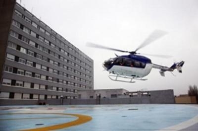
GNSS-SBAS guidance also enhances both the precision and the performance of rotorcraft navigation. In particular, curved procedures enable rotorcraft to operate under IFR in challenging environments such as mountainous areas and to fly safely steep approaches to airports or heliports that are difficult to access or located in densely populated areas. This is particularly important for medical air transport to city hospitals or for helicopter operations in the vicinity of airports without interfering with the surrounding fixed-wing aircraft traffic.
(Image provided by Egis Avia)
More News
Say Altitude Used by ATC to ascertain an aircraft's specific altitude/flight level. When the aircraft is climbing or descending, the pilot should state the indicated altitude round>[...]
Aero Linx: European Air Law Association (EALA) EALA was established in 1988 with the aim to promote the study of European air law and to provide an open forum for those with an int>[...]
From 2023 (YouTube Version): The Life, Death, Life, Death, and Life of a Glorious Warbird In 1981, business-owner Jim Tobul and his father purchased a Chance-Vought F4U Corsair. Mo>[...]
Also: USCG Retires MH-65 Dolphins, Irish Aviation Authority, NATCA Warns FAA, Diamond DA42 AD This summer, history enthusiasts will have a unique opportunity to experience World Wa>[...]
Also: WACO Kitchen Bails, French SportPlane Mfr to FL, Dynon-Advance Flight Systems, Innovation Preview Bobby Bailey, a bit of a fixture in sport aviation circles for his work with>[...]
 ANN's Daily Aero-Term (05.01.24): Say Altitude

