Thu, Feb 18, 2010
Compatible With The GNS 430W/530W Family
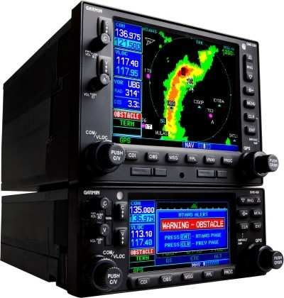
 Garmin
International has unveiled a new Helicopter Terrain Awareness and
Warning System (HTAWS) for the GNS 430W/530W series navigators.
HTAWS is available as an option on newly purchased systems or as a
field upgrade for current owners. When added to the GNS 430W/530W
navigators, operators will receive graphical and audible alerts of
potential terrain and obstacle conflicts along the flight path. The
announcement was made Thursday afternoon.
Garmin
International has unveiled a new Helicopter Terrain Awareness and
Warning System (HTAWS) for the GNS 430W/530W series navigators.
HTAWS is available as an option on newly purchased systems or as a
field upgrade for current owners. When added to the GNS 430W/530W
navigators, operators will receive graphical and audible alerts of
potential terrain and obstacle conflicts along the flight path. The
announcement was made Thursday afternoon.
"Garmin is serious about safety, and HTAWS is life saving
technology that will increase safety of flight," said Gary Kelley,
Garmin's vice president of marketing.
Garmin's HTAWS has forward looking terrain avoidance (FLTA)
capability with visual and aural advisories to keep pilots advised
of hazardous terrain. It incorporates a new five color terrain
scale (red, orange, yellow, green and black), and also gives
terrain voice alerts when descending below 500 feet. Voice callouts
operate in all HTAWS modes, and Garmin's technology allows the
pilot to select multiple callouts, in one hundred foot intervals,
descending from 500 to 100 feet above ground level (AGL). In
addition, Garmin's HTAWS offers a reduced protection (RP) mode that
allows low-level operations with minimal alerting while continuing
to provide terrain and obstacle protection.
Garmin has incorporated three new helicopter specific databases
for HTAWS. The obstacle database adds nearly 30,000 additional
low-altitude obstacles. The new terrain database has been enhanced
to show higher resolution. The navigation database lets operators
navigate to over 7,000 heliports without having to create user
waypoints at those locations.
In addition to viewing HTAWS information on the GNS 430W/530W
series, rotorcraft operators who have also installed the new G500H
can display all HTAWS annunciations on the G500H's large PFD and
MFD.
Garmin's HTAWS is expected to be certified and available in the
second quarter of 2010 for $9,995 as a field-upgrade or as an
option on new GNS 430W/530W series products.
More News
From 2023 (YouTube Version): Legacy of a Titan Robert (Bob) Anderson Hoover was a fighter pilot, test pilot, flight instructor, and air show superstar. More so, Bob Hoover was an i>[...]
Get The Latest in Aviation News NOW on Instagram Are you on Instagram yet? It's been around for a few years, quietly picking up traction mostly thanks to everybody's new obsession >[...]
Aero Linx: B-52H Stratofortress The B-52H Stratofortress is a long-range, heavy bomber that can perform a variety of missions. The bomber is capable of flying at high subsonic spee>[...]
Altimeter Setting The barometric pressure reading used to adjust a pressure altimeter for variations in existing atmospheric pressure or to the standard altimeter setting (29.92).>[...]
"Knowing that we play an active part in bettering people's lives is extremely rewarding. My team and I are very thankful for the opportunity to be here and to help in any way we ca>[...]
 Classic Aero-TV: Remembering Bob Hoover

