Will Study Changes In The Antarctic Ice Sheet
 NASA begins a series of flights
Oct. 15 to study changes to Antarctica's sea ice, glaciers and ice
sheets. The flights are part of Operation Ice Bridge, a six-year
campaign that is the largest airborne survey ever made of ice at
Earth's polar regions.
NASA begins a series of flights
Oct. 15 to study changes to Antarctica's sea ice, glaciers and ice
sheets. The flights are part of Operation Ice Bridge, a six-year
campaign that is the largest airborne survey ever made of ice at
Earth's polar regions.
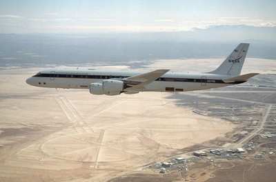
Researchers will work from NASA's DC-8, an airborne laboratory
equipped with laser mapping instruments, ice-penetrating radar and
gravity instruments. Data collected from the mission will help
scientists better predict how changes to the massive Antarctic ice
sheet will contribute to future sea level rise around the
world.
The plane, crew and scientists depart Oct. 12 from NASA's Dryden
Aircraft Operations Facility in Palmdale, California, and fly to
Punta Arenas, Chile, where they will be based through mid-November.
Seelye Martin of the University of Washington in Seattle leads the
mission, with nearly 50 scientists and support personnel involved.
The team is planning 17 flights over some of the fastest-changing
areas in western Antarctica and its ice-covered coastal waters.
Data collected during the campaign also will help bridge the
data gap between NASA's Ice, Cloud, and Land Elevation Satellite,
known as ICESat, which has been in orbit since 2003, and NASA's
ICESat-II, scheduled to launch no earlier than 2014. ICESat is
nearing the end of its operational lifetime, making the Ice Bridge
flights critical for ensuring a continuous record of
observations.
"A remarkable change is happening on Earth, truly one of the
biggest changes in environmental conditions since the end of the
ice age," said Tom Wagner, cryosphere program manager at NASA
Headquarters in Washington. "It's not an easy thing to observe, let
alone predict what might happen next. Studies like Ice Bridge are
key."
Because airborne observations lack the continent-wide coverage a
satellite provides, mission planners have selected key targets to
study that are most prone to change. Sea ice measurements will be
collected from the Amundsen Sea, where local warming suggests the
ice may be thinning. Ice sheet and glacier studies will be flown
over the Antarctic Peninsula and West Antarctica, including Pine
Island Glacier, an area scientists believe could undergo rapid
changes.
The payload on the DC-8 includes the Airborne Topographic
Mapper, a laser altimeter developed at NASA's Wallops Flight
Facility in Virginia. It produces elevation maps of the ice surface
and previously was flown over the Antarctic in 2002, 2004, and 2008
aboard a Chilean Navy P3 aircraft. By retracing some of those
flights, as well as the tracks covered by ICESat, researchers can
compare the data sets and determine changes in ice elevation.
Other instruments flying include the Multichannel Coherent Radar
Depth Sounder from the University of Kansas, which measures ice
sheet thickness and the varied terrain below the ice. The Laser
Vegetation Imaging Sensor, developed at NASA's Goddard Space Flight
Center in Greenbelt, MD, maps large areas of sea ice and glacier
zones. A gravimeter from Columbia University's Lamont-Doherty Earth
Observatory in Palisades, NY, will give scientists their first
opportunity to measure the shape of the ocean cavity beneath
floating ice shelves in critical spots of Antarctica. A University
of Kansas snow radar will measure the thickness of snow on top of
sea ice and glaciers.
NASA's Langley Research Center in Hampton, Virginia; NASA's Ames
Research Center in Moffett Field, California: and the University of
North Dakota in Grand Forks also are providing support for the
campaign.
NASA also is funding complementary airborne surveys as part of
Operation Ice Bridge, including surveys of Alaskan glaciers by
scientists from the University of Alaska in Fairbanks and an
extensive survey of remote regions of East Antarctica by scientists
from the University of Texas in Austin, the University of Edinburgh
and the Australian Antarctic Division.
The Antarctic flights follow the first Operation Ice Bridge
airborne campaign earlier this year over Greenland and the Arctic
Ocean. The mission will map key areas in each polar region once a
year. Arctic flights resume in spring 2010.
 ANN's Daily Aero-Term (05.01.24): Say Altitude

