Wed, Mar 04, 2015
Eight Major Metro Areas, Gulf Of Mexico Included In First Release
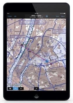
Garmin is rolling out a new version of Garmin Pilot for iOS, which adds a suite of features tailored to helicopter operators. These features incorporate helicopter route charts throughout eight U.S. metropolitan areas, including the Gulf of Mexico. Additionally, the latest version of Garmin Pilot allows pilots to easily identify and document the highest obstacle along their flight plan route, which fulfills Part 135 Helicopter Emergency Medical Service (HEMS) requirements set forth by the FAA.
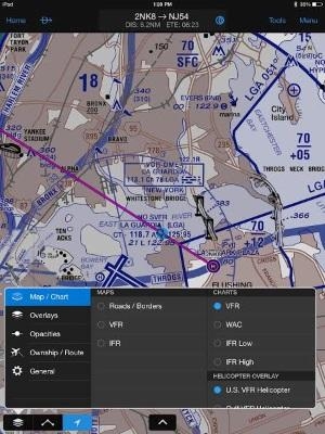
Helicopter Route Charts within Garmin Pilot provide detailed information applicable to the unique operations carried out by these operators. These three-color charts depict helicopter airways and routes, heliports with associated frequency and lighting capabilities, NAVAID information and obstructions. Additionally, pictorial symbols, roads and geographical features are notated on these charts for easier identification in urban areas with high concentrations of helicopter activity.
Garmin Pilot includes VFR and IFR Helicopter Route Charts for eight major metropolitan areas, including:
- Baltimore
- Boston
- Chicago
- Dallas-Ft.Worth
- Detroit
- Houston
- Los Angeles
- New York
Coverage for the Gulf of Mexico is also available, which includes offshore oil drilling platforms and more.
For helicopter air ambulance operators, rules recently established by the FAA requiring pilots to identify and document the highest obstacle along a planned route (§ 135.615), can now fulfill those requirements within Garmin Pilot. When entering a departure and destination airport pair, Garmin Pilot conveniently identifies the highest obstacle along the route of flight in mean sea level (MSL) and above ground level (AGL) within the Flight Plan page and notates the obstacle graphically on the moving map page.
The latest version of Garmin Pilot for iOS is available immediately as a free update, providing operators access to additional chart information tailored to helicopter operators and the opportunity to conveniently meet HEMS requirements.
(Images provided by Garmin)
FMI: www.garmin.com
More News
From 2023 (YouTube Version): Legacy of a Titan Robert (Bob) Anderson Hoover was a fighter pilot, test pilot, flight instructor, and air show superstar. More so, Bob Hoover was an i>[...]
Get The Latest in Aviation News NOW on Instagram Are you on Instagram yet? It's been around for a few years, quietly picking up traction mostly thanks to everybody's new obsession >[...]
Aero Linx: B-52H Stratofortress The B-52H Stratofortress is a long-range, heavy bomber that can perform a variety of missions. The bomber is capable of flying at high subsonic spee>[...]
Altimeter Setting The barometric pressure reading used to adjust a pressure altimeter for variations in existing atmospheric pressure or to the standard altimeter setting (29.92).>[...]
"Knowing that we play an active part in bettering people's lives is extremely rewarding. My team and I are very thankful for the opportunity to be here and to help in any way we ca>[...]
 Classic Aero-TV: Remembering Bob Hoover

