NavAidDrone: A New Drone-Based Measurement System For NAVAID Inspection | Aero-News Network
Aero-News Network
RSS icon RSS feed
podcast icon MP3 podcast
Subscribe Aero-News e-mail Newsletter Subscribe

Airborne Unlimited -- Most Recent Daily Episodes

Episode Date

Airborne-Monday

Airborne-Tuesday

Airborne-Wednesday Airborne-Thursday

Airborne-Friday

Airborne On YouTube

Airborne-Unlimited-05.06.24

Airborne-NextGen-04.30.24

Airborne-Unlimited-05.01.24 Airborne-AffordableFlyers--05.02.24

Airborne-Unlimited-05.03.24

Wed, Mar 07, 2018

NavAidDrone: A New Drone-Based Measurement System For NAVAID Inspection

System Can Be Modified To Perform VOR And GBAS Measurements

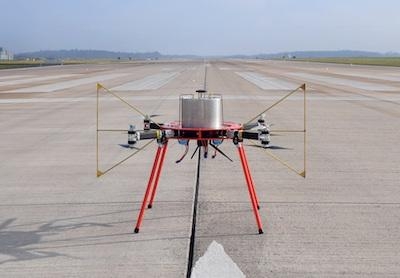
Following a joint-development effort with FCS Flight Calibration Services GmbH, LS telcom’s Colibrex announces the launch of NavAidDrone, a drone-based system for navigational aid (NAVAID) inspections.

The NavAidDrone is used for field measurements required for commissioning and regular maintenance of Instrument Landing Systems (ILS). It will support Air Navigation Service Providers, NAVAID system manufacturers, and CNS (communication, navigation, surveillance) installation and maintenance service engineers. The system can also perform VOR and GBAS measurements with additional software included.

Measurement data, processed by the NavAidDrone, will now be available for areas that cannot be accessed by vehicles or conventional telescopic masts and for which measurement was therefore previously not possible. For instance, the NavAidDrone measures localizer coverage with ease in a sector of ± 35° towards the antenna as it can be fully programmed to fly orbit paths. The airborne measurement system can also detect high frequency oscillations of ILS signals caused by buildings, cranes or other construction work obstacles.

"The integrated high-performing FCS receiver guarantees extremely accurate measurement results. At the same time, the flexible airborne platform delivers a much higher volume of measurement points and results, compared to ground measurements," said Luc Haeberlé, Managing Director of Colibrex. "Altogether, the measurement results obtained with the NavAidDrone are much more comprehensive and precise and improve ILS periodical measurements, adjustment and maintenance work substantially. At the same time, the use of NavAidDrone is more cost-effective and will also potentially reduce flight inspection hours.”

"Drone-based ILS measurement opens the way to a new era in NAVAIDS inspection and FCS together with Colibrex are at the forefront of this exciting and complementary approach to flight inspection," said Rüdiger Schmidt, Managing Director of FCS. "Flight inspection and ground measurements should go hand in hand to ensure the best performance of our client's NavAids. Our exciting new technology very effectively bridges the gap between the two worlds.”

The NavAidDrone unites the flight inspection and receiving and processing expertise of FCS Flight Calibration Services GmbH and Colibrex’s expertise in the design and international commercial operation of unmanned aircraft systems for radio frequency measurements.

Colibrex and FCS are planning a follow-up development and launch of the “RadarDrone” to perform field measurements for commissioning, troubleshooting and regular maintenance of military and civil radar and surveillance systems, including primary (PR) and secondary (SSR/MSSR) radar installations. The Air Navigation Service Providers and CNS maintenance staff, radar system manufacturers and radar service organisations will benefit from this new drone-based measurement technology.

(Images provided with Colibrex and FCS Flight Calibration Services news release)

FMI: www.Colibrex.com, www.LStelcom.com, cs.aero/english

Advertisement

More News

ANN's Daily Aero-Term (05.09.24): Hold Procedure

Hold Procedure A predetermined maneuver which keeps aircraft within a specified airspace while awaiting further clearance from air traffic control. Also used during ground operatio>[...]

ANN's Daily Aero-Term (05.06.24): Altitude Readout

Altitude Readout An aircraft’s altitude, transmitted via the Mode C transponder feature, that is visually displayed in 100-foot increments on a radar scope having readout cap>[...]

ANN's Daily Aero-Linx (05.06.24)

Aero Linx: European Hang Gliding and Paragliding Union (EHPU) The general aim of the EHPU is to promote and protect hang gliding and paragliding in Europe. In order to achieve this>[...]

Airborne-NextGen 05.07.24: AI-Piloted F-16, AgEagle, 1st 2 WorldView Sats

Also: Skydio Chief, Uncle Sam Sues, Dash 7 magniX, OR UAS Accelerator US Secretary of the Air Force Frank Kendall was given a turn around the patch in the 'X-62A Variable In-flight>[...]

Aero-News: Quote of the Day (05.07.24)

"The need for innovation at speed and scale is greater than ever. The X-62A VISTA is a crucial platform in our efforts to develop, test and integrate AI, as well as to establish AI>[...]

blog comments powered by Disqus


Advertisement

Advertisement

Podcasts

Advertisement

© 2007 - 2024 Web Development & Design by Pauli Systems, LC