Thu, Aug 16, 2018
High Resolution Satellite Imagery Used To Speed Claims Processing
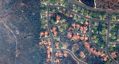
Powered by Airbus Aerial’s data analytics and high-resolution satellite imagery from Airbus Intelligence, insurance companies are helping their policyholders begin to recover from the tragic Carr wildfires — already one of the top ten most destructive wildfires in California history. At present, these wildfires continue to burn and are only 27% contained.
Thanks to Aerial’s cloud platform, insurance damage triage tool kit, and suite of analytics, blended with satellite imagery of targeted areas from Airbus Intelligence, insurance companies can usually process a claim and inform their customers before the customer even knows a loss has occurred.
It is critical for insurers to quickly understand the impacts to their insured assets and policyholders to help their customers restore their lives as soon as possible. Airbus Aerial’s services help enable insurance companies to process and pay claims remotely – even as fires continue to burn – better enabling policyholders to secure long-term housing and restore their lives quickly. Using before/after aerial imagery of an affected area also helps insurance companies reduce costs associated with assessing claims.
Aerial directly tasks Airbus high-resolution satellites to capture data exactly around the locations of greatest interest to our customers. Within hours, this data is processed in Aerial’s cloud-based data platform. Next, Aerial’s proprietary machine-learning algorithms take this data and highlight the properties that are completely destroyed and a total loss.
These wildfires offer a prime example of the benefit of multiple aerial data sources. In this case, drones and manned aircraft cannot be used to make way for first responders, or for damage assessments by insurance companies because of poor visibility due to smoke and ash, as well as airspace flying restrictions.
Aerial has delivered these types of essential services to major insurance companies in times of disaster before. In 2017 during Hurricanes Harvey and Irma, which caused between $150 billion and $200 billion in damage to Texas and Florida, Aerial provided analytics and imagery from drones, manned and unmanned aircraft and from satellites to help insurance companies settle claims quickly and efficiently.
(Image provided with Airbus Aerial news release)
More News
Very High Frequency The frequency band between 30 and 300 MHz. Portions of this band, 108 to 118 MHz, are used for certain NAVAIDs; 118 to 136 MHz are used for civil air/ground voi>[...]
Aero Linx: Aviation Suppliers Association Established February 25, 1993, the Aviation Suppliers Association (ASA), based in Washington, D.C., is a not-for-profit association, repre>[...]
Have A Story That NEEDS To Be Featured On Aero-News? Here’s How To Submit A Story To Our Team Some of the greatest new stories ANN has ever covered have been submitted by our>[...]
From 2021 (YouTube Version): Colorado Campus Offers aVariety Of Aerospace Entertainment And Education Wings over the Rockies Exploration of Flight is the second location for the Wi>[...]
Also: Paramotor Champ's, Electric Ultralight, ICON BK Update, Burt Rutan at Oshkosh! The Popular Rotorcraft Association is reaching out for help in rebuilding their private runway >[...]
 ANN's Daily Aero-Term (05.17.24): Very High Frequency

