Mon, Feb 18, 2019
Interferograms Derive The Topographic Elevation And Deformation Of The Earth’s Surface
Airbus Defense and Space and Hisdesat Servicios Estratégicos, S.A. have generated the first joint TerraSAR-X / PAZ Radar Interferogram. This milestone demonstrates the missions’ capacity for cross-sensor interferometry, whose processing is among the most challenging.
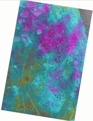
Interferograms are typically used to derive the topographic elevation and deformation of the Earth’s surface, and are created using at least two different images acquired at different date. This flattened Cross-Sensor-Interferogram has been created from a mixed image pair with 4 days temporal separation acquired by TerraSAR-X and PAZ (StripMap scenes from November 22 and 26, 2018). The area covers the oil and gas production site Burgan (Kuwait) and parts of the Persian Gulf. The oil field is the world largest sandstone oil field with the total surface area of about 386 square miles.
As PAZ is positioned in the same orbit as TerraSAR-X and TanDEM-X and features exactly identical ground swaths and acquisition modes, they all three form a high-resolution SAR satellite constellation, jointly exploited by Hisdesat and Airbus. With the launch of PAZ, the observation repeat cycle has been divided by half, which improves the monitoring of fast ground deformation phenomena that can endanger lives and infrastructures.
“This is a major step towards achieving the implementation of our TerraSAR-X / PAZ Radar Constellation. The level of accuracy obtained with this interferogram is a guarantee for our customers to continue to rely on the high quality standard we have set with TerraSAR-X and TanDEM-X, but with an improved monitoring capacitiy” said Hanjo Kahabka, Head of Production and Radar Constellation Manager at Airbus Defense and Space, Intelligence.
“In Hisdesat we are very proud of reaching this milestone. Interferometry is one of the most technically demanding applications and thanks to this successful joint exercise with Airbus we have not only demonstrated the top performance of our PAZ satellite but its full compatibility with TerraSAR-X and TanDEM-X. Now operation in constellation can become a reality and we will be able to provide to our customers full set of images and services with the constellation.” said Miguel García Primo, Chief Operating Officer at Hisdesat.
(Image provided with Airbus news release)
More News
Aero Linx: Model Aeronautical Association of Australia MAAA clubs are about fun flying, camaraderie and community. For over 75 years, the MAAA has been Australia’s largest fl>[...]
Touchdown Zone Lighting Two rows of transverse light bars located symmetrically about the runway centerline normally at 100 foot intervals. The basic system extends 3,000 feet alon>[...]
“Discovery and innovation are central to our mission at Virgin Galactic. We’re excited to build on our successful record of facilitating scientific experiments in subor>[...]
How To Get A Story On Aero-TV News/Feature Programming How do I submit a story idea or lead to Aero-TV? If you would like to submit a story idea or lead, please contact Jim Campbel>[...]
Student Pilot Reported That During Rotation, “All Of A Sudden The Back Of The Plane Kicked To The Right..." Analysis: The student pilot reported that during rotation, “>[...]
 ANN's Daily Aero-Linx (05.02.24)

