NASA Spacecraft Penetrates Mysteries Of Martian Ice Cap
 Data from NASA's Mars Reconnaissance Orbiter (MRO) have helped
scientists solve a pair of mysteries dating back four decades and
provided new information about climate change on the Red
Planet.
Data from NASA's Mars Reconnaissance Orbiter (MRO) have helped
scientists solve a pair of mysteries dating back four decades and
provided new information about climate change on the Red
Planet.
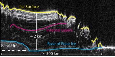
The Shallow Radar, or SHARAD, instrument aboard MRO revealed
subsurface geology allowing scientists to reconstruct the formation
of a large chasm and a series of spiral troughs on the northern ice
cap of Mars. The findings appear in two papers in the May 27 issue
of the journal Nature.
"SHARAD is giving us a beautifully detailed view of ice
deposits, whether at the poles or buried in mid-latitudes, as they
changed on Mars over the last few million years," said Rich Zurek,
MRO project scientist at NASA's Jet Propulsion Laboratory in
Pasadena, CA.
On Earth, large ice sheets are shaped mainly by ice flow.
According to this latest research, other forces have shaped, and
continue to shape, polar ice caps on Mars. The northern ice cap is
a stack of ice and dust layers up to two miles deep, covering an
area slightly larger than Texas. Analyzing radar data on a
computer, scientists can peel back the layers like an onion to
reveal how the ice cap evolved over time.
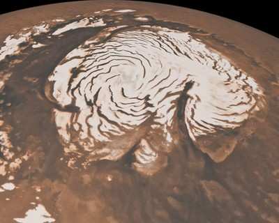
Chasma Boreale To Right, NASA Image
One of the most distinctive features of the northern ice cap is
Chasma Boreale, a canyon about as long as Earth's Grand Canyon but
deeper and wider. Some scientists believe Chasma Boreale was
created when volcanic heat melted the bottom of the ice sheet and
triggered a catastrophic flood. Others suggest strong polar winds
carved the canyon out of a dome of ice.
Other enigmatic features of the ice cap are troughs that spiral
outward from the center like a gigantic pinwheel. Since the troughs
were discovered in 1972, scientists have proposed several
hypotheses about how they formed. Perhaps as Mars spins, ice closer
to the poles moves slower than ice farther away, causing the
semi-fluid ice to crack. Perhaps, as one mathematical model
suggests, increased solar heating in certain areas and lateral heat
conduction could cause the troughs to assemble.
Data from Mars now points to both the canyon and spiral troughs
being created and shaped primarily by wind. Rather than being cut
into existing ice very recently, the features formed over millions
of years as the ice sheet grew. By influencing wind patterns, the
shape of underlying, older ice controlled where and how the
features grew.
"Nobody realized that there would be such complex structures in
the layers," said Jack Holt, of the University of Texas at Austin's
Institute for Geophysics. Holt is the lead author of the paper
focusing on Chasma Boreale. "The layers record a history of ice
accumulation, erosion and wind transport. From that, we can recover
a history of climate that's much more detailed than anybody
expected."
The Mars Reconnaissance Orbiter was launched on Aug. 12, 2005.
SHARAD and the spacecraft's five other instruments began science
operations in November 2006.
NASA Mars Reconnaissance Orbiter Ice Analysis
"These anomalous features have gone unexplained for 40 years
because we have not been able to see what lies beneath the
surface," said Roberto Seu, SHARAD team leader at the University of
Rome. "It is gratifying to me that with this new instrument we can
finally explain them."
The MRO mission is managed by JPL for the Mars Exploration
Program at NASA's Headquarters in Washington. SHARAD was provided
by the Italian Space Agency, and its operations are led by the
InfoCom Department, University of Rome.
 ANN's Daily Aero-Term (05.09.24): Hold Procedure

