NASA Maps Beirut Blast Damage | Aero-News Network
Aero-News Network
RSS icon RSS feed
podcast icon MP3 podcast
Subscribe Aero-News e-mail Newsletter Subscribe

Airborne Unlimited -- Most Recent Daily Episodes

Episode Date

Airborne-Monday

Airborne-Tuesday

Airborne-Wednesday Airborne-Thursday

Airborne-Friday

Airborne On YouTube

Airborne-Unlimited-05.13.24

Airborne-NextGen-05.07.24

Airborne-Unlimited-05.08.24 Airborne-FlightTraining-05.09.24

Airborne-Unlimited-05.10.24

Sun, Aug 09, 2020

NASA Maps Beirut Blast Damage

Satellite-Derived Synthetic Aperture Radar Data Shows Massive Effect

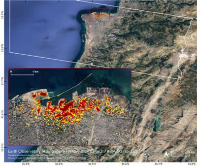
NASA's Advanced Rapid Imaging and Analysis (ARIA) team, in collaboration with the Earth Observatory of Singapore, used satellite-derived synthetic aperture radar data to map the likely extent of damage from a massive Aug. 4 explosion in Beirut.

Synthetic aperture radar data from space shows ground surface changes from before and after a major event like an earthquake. In this case, it is being used to show the devastating result of an explosion.

On the map, dark red pixels – like those present at and around the Port of Beirut – represent the most severe damage. Areas in orange are moderately damaged and areas in yellow are likely to have sustained somewhat less damage. Each colored pixel represents an area of 30 meters.

Maps like this one can help identify badly damaged areas where people may need assistance. The explosion occurred near the city's port. It claimed more than 150 lives and is estimated to have caused billions of dollars' worth of damage.

The map contains modified Copernicus Sentinel data processed by ESA (European Space Agency) and analyzed by ARIA team scientists at NASA JPL, Caltech, and Earth Observatory of Singapore. Located in Pasadena, California, Caltech manages JPL for NASA.

FMI: https://aria.jpl.nasa.gov/

Advertisement

More News

ANN's Daily Aero-Term (05.10.24): Takeoff Roll

Takeoff Roll The process whereby an aircraft is aligned with the runway centerline and the aircraft is moving with the intent to take off. For helicopters, this pertains to the act>[...]

Aero-News: Quote of the Day (05.10.24)

“We’re proud of the hard work that went into receiving this validation, and it will be a welcome relief to our customers in the European Union. We couldn’t be mor>[...]

Aero-News: Quote of the Day (05.11.24)

"Aircraft Spruce is pleased to announce the acquisition of the parts distribution operations of Wag-Aero. Wag-Aero was founded in the 1960’s by Dick and Bobbie Wagner in the >[...]

ANN's Daily Aero-Term (05.11.24): IDENT Feature

IDENT Feature The special feature in the Air Traffic Control Radar Beacon System (ATCRBS) equipment. It is used to immediately distinguish one displayed beacon target from other be>[...]

ANN's Daily Aero-Linx (05.11.24)

Aero Linx: Pararescue Air Force Pararescuemen, also known as PJs, are the only DoD elite combat forces specifically organized, trained, equipped, and postured to conduct full spect>[...]

blog comments powered by Disqus


Advertisement

Advertisement

Podcasts

Advertisement

© 2007 - 2024 Web Development & Design by Pauli Systems, LC