Insitu Receives Interior Contract For Small UAS Services | Aero-News Network
Aero-News Network
RSS icon RSS feed
podcast icon MP3 podcast
Subscribe Aero-News e-mail Newsletter Subscribe

Airborne Unlimited -- Most Recent Daily Episodes

Episode Date

Airborne-Monday

Airborne-Tuesday

Airborne-Wednesday Airborne-Thursday

Airborne-Friday

Airborne On YouTube

Airborne-Unlimited-05.06.24

Airborne-NextGen-05.07.24

Airborne-Unlimited-05.08.24 Airborne-FlightTraining-05.09.24

Airborne-Unlimited-05.10.24

Mon, Jun 25, 2018

Insitu Receives Interior Contract For Small UAS Services

Unmanned Aircraft Systems Will Assist In Combating Wildfires Using Geospatial Mapping And Full Motion Video

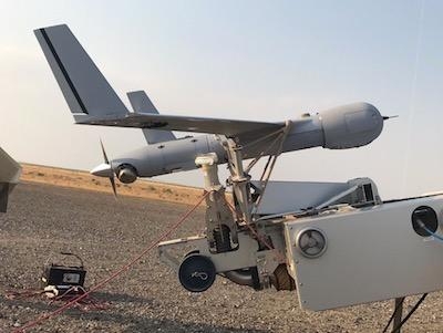
The Department of the Interior has awarded a  first-of-its kind contract to Boeing subsidiary Insitu to provide fire suppression services within the contiguous 48 states and Alaska using its ScanEagle Unmanned Aircraft System (UAS).

Per the contract, Insitu will support manned aerial operations Including fire suppression, search and rescue, emergency management, and other operations as needed on a "call when needed" basis.

"We are honored that Insitu has been selected to bring our professional aviation, aerial data collection and analysis experience to assist the DOI as they strive to suppress devastating wildfires," said Esina Alic, Insitu's president and CEO.

Equipped with Infrared and electro-optical cameras, sensors, and a customized TK-5 Firewatch smart tactical mapping payload, ScanEagle will provide near real-time fire line maps and wide-area, high-resolution imagery intelligence to assist with fire suppression planning. With these payloads onboard, ScanEagle can "fly the gaps," operating in dense smoke and darkness, when manned aircraft typically are grounded due to hazardous flying conditions for pilots.

As demonstrated in 2017 during the nearly 50,000 acre Eagle Creek, Oregon fire, as well as two wildfires in Northern California, Insitu's ScanEagle used aerial sensors allowing data gathering, analysis and dissemination to deliver critical situational awareness for incident commanders. This critical near-real time information allowed informed decision-making for more effectively and safely deploying firefighters. ScanEagle provided near real-time full motion video and geospatial mapping to pinpoint hot spots and locate fire lines in the rugged terrain.

During wildfires, UASs operate within Temporary Flight Restrictions (TFRs) established over large-area wildfires. This work is done in collaboration with the Federal Aviation Administration to allow beyond visual line of sight flight operations — a critical capability in the smoky wildfire environment — while keeping other aircraft aware and safe.

(Image provided with Insitu news release)

FMI: www.insitu.com

Advertisement

More News

Airborne-Flight Training 05.09.24: ERAU at AIAA, LIFT Diamond Buy, Epic A&P

Also: Vertical Flight Society, NBAA Maintenance Conference, GA Honored, AMT Scholarship For the first time, students from Embry-Riddle’s Daytona Beach, Florida, campus took t>[...]

ANN's Daily Aero-Term (05.07.24): Hazardous Weather Information

Hazardous Weather Information Summary of significant meteorological information (SIGMET/WS), convective significant meteorological information (convective SIGMET/WST), urgent pilot>[...]

Aero-News: Quote of the Day (05.07.24)

"The need for innovation at speed and scale is greater than ever. The X-62A VISTA is a crucial platform in our efforts to develop, test and integrate AI, as well as to establish AI>[...]

NTSB Final Report: Cessna 150

(FAA) Inspector Observed That Both Fuel Tanks Were Intact And That Only A Minimal Amount Of Fuel Remained In Each Analysis: According to the pilot, approximately 8 miles from the d>[...]

Aero-News: Quote of the Day (05.08.24)

“Pyka’s Pelican Cargo is unlike any other UAS solution on the market for contested logistics. We assessed a number of leading capabilities and concluded that the Pelica>[...]

blog comments powered by Disqus


Advertisement

Advertisement

Podcasts

Advertisement

© 2007 - 2024 Web Development & Design by Pauli Systems, LC