ANN's Daily Aero-Tips (08.01.06): Satellite View | Aero-News Network
Aero-News Network
RSS icon RSS feed
podcast icon MP3 podcast
Subscribe Aero-News e-mail Newsletter Subscribe

Airborne Unlimited -- Most Recent Daily Episodes

Episode Date

Airborne-Monday

Airborne-Tuesday

Airborne-Wednesday Airborne-Thursday

Airborne-Friday

Airborne On YouTube

Airborne-Unlimited-04.22.24

Airborne-Unlimited-04.16.24

Airborne-FlightTraining-04.17.24 Airborne-AffordableFlyers-04.18.24

Airborne-Unlimited-04.19.24

Join Us At 0900ET, Friday, 4/10, for the LIVE Morning Brief.
Watch It LIVE at
www.airborne-live.net

Tue, Aug 01, 2006

ANN's Daily Aero-Tips (08.01.06): Satellite View

Aero-Tips!

A good pilot is always learning -- how many times have you heard this old standard throughout your flying career? There is no truer statement in all of flying (well, with the possible exception of "there are no old, bold pilots.")

Aero-News has called upon the expertise of Thomas P. Turner, master CFI and all-around-good-guy, to bring our readers -- and us -- daily tips to improve our skills as aviators. Some of them, you may have heard before... but for each of us, there will also be something we might never have considered before, or something that didn't "stick" the way it should have the first time we memorized it for the practical test.

Look for our daily Aero-Tips segments, coming each day to you through the Aero-News Network.

Aero-Tips 08.01.06

One tool useful in making a broad go/no-go decision is the satellite view. Radar shows precipitation, but satellite pictures show more extensive cloud cover even away from rain or snow.

There are actually three types of satellite view -- the visible cloud cover chart, the infrared satellite view, and the water vapor imagery.

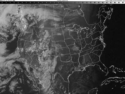
The visible cloud cover chart is just that -- a photograph from space that shows areas of cloud cover. The brighter the cloud image the higher the cloud tops, which may correlate to thunderstorms but may also depict harmless high cirrus clouds.

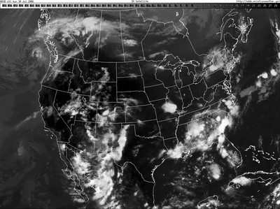
Note the eastern part of the U.S. appears dark-it's after sunset in the east, so there's no sunlight to reflect off the cloud tops and the picture is about meaningless. All is not lost-there's also an infrared view for nighttime imagery. The infrared is available both in black and white and color.

Look at New York State in the visible and infrared images -- what looks benign on the nighttime satellite chart in instead potentially hazardous on the infrared. Look also in the area near St. Louis, Missouri, and you'll see that, in daylight, the visible and infrared images correlate closely.

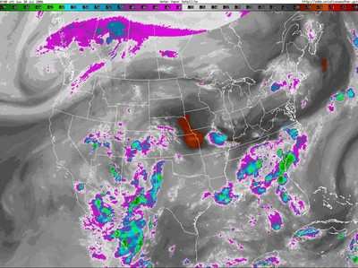
The water vapor image takes this a step further, graphically showing where the air is its wettest, giving the highest potential for storms or extensive cloudiness.

Remember that moist air cooling at night can create low clouds and poor visibility in fog. The area west of Missouri's high clouds shows a lot of moisture, for instance -- pointing to possible evening storms or reduced visibility as the evening air cools and promotes condensation.

Note that on all satellite views you're seeing the tops of the highest layer of clouds or vapor... not what lies underneath. Taken together, they show areas of extensive cloudiness, the possibility of storms and, perhaps most notably, the availability of abundant moisture that may develop into clouds, fog or storms.

Aero-tip of the day: Supplement your preflight self-brief with a look at the visible and infrared satellite images, and the water vapor imagery.

FMI: Aero-Tips

Advertisement

More News

Airbus Racer Helicopter Demonstrator First Flight Part of Clean Sky 2 Initiative

Airbus Racer Demonstrator Makes Inaugural Flight Airbus Helicopters' ambitious Racer demonstrator has achieved its inaugural flight as part of the Clean Sky 2 initiative, a corners>[...]

Diamond's Electric DA40 Finds Fans at Dübendorf

A little Bit Quieter, Said Testers, But in the End it's Still a DA40 Diamond Aircraft recently completed a little pilot project with Lufthansa Aviation Training, putting a pair of >[...]

ANN's Daily Aero-Term (04.23.24): Line Up And Wait (LUAW)

Line Up And Wait (LUAW) Used by ATC to inform a pilot to taxi onto the departure runway to line up and wait. It is not authorization for takeoff. It is used when takeoff clearance >[...]

NTSB Final Report: Extra Flugzeugbau GMBH EA300/L

Contributing To The Accident Was The Pilot’s Use Of Methamphetamine... Analysis: The pilot departed on a local flight to perform low-altitude maneuvers in a nearby desert val>[...]

Classic Aero-TV: 'Never Give Up' - Advice From Two of FedEx's Female Captains

From 2015 (YouTube Version): Overcoming Obstacles To Achieve Their Dreams… At EAA AirVenture 2015, FedEx arrived with one of their Airbus freight-hauling aircraft and placed>[...]

blog comments powered by Disqus


Advertisement

Advertisement

Podcasts

Advertisement

© 2007 - 2024 Web Development & Design by Pauli Systems, LC