GOES-17 Mishap Investigation Board Study Completed | Aero-News Network
Aero-News Network
RSS icon RSS feed
podcast icon MP3 podcast
Subscribe Aero-News e-mail Newsletter Subscribe

Airborne Unlimited -- Most Recent Daily Episodes

Episode Date

Airborne-Monday

Airborne-Tuesday

Airborne-Wednesday Airborne-Thursday

Airborne-Friday

Airborne On YouTube

Airborne-Unlimited-05.13.24

Airborne-NextGen-05.07.24

Airborne-Unlimited-05.08.24 Airborne-FlightTraining-05.09.24

Airborne-Unlimited-05.10.24

Wed, Aug 07, 2019

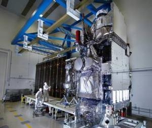
GOES-17 Mishap Investigation Board Study Completed

Most Likely Cause Of The ABI Cooling Issue Is A Blockage In The Instrument’s Loop Heat Pipes

A Mishap Investigation Board appointed by NASA and the National Oceanic and Atmospheric Administration (NOAA) has identified the most likely cause for an instrument issue aboard NOAA’s Geostationary Operational Environmental Satellite (GOES)-17 satellite that launched March 1, 2018 from Cape Canaveral Air Force Station in Florida.

During postlaunch testing of the satellite’s Advanced Baseline Imager (ABI), teams discovered the instrument’s infrared detectors could not be maintained at the required temperatures during some orbital conditions, which resulted in a partial loss of three of the instruments 16 bands during certain times of the year.

The ABI is GOES-17’s primary instrument for imaging Earth’s weather, oceans, and environment. It views the Earth with 16 spectral bands including two visible, four near-infrared, and 10 infrared channels.

The mishap board was tasked with gathering and analyzing information, and identifying the proximate causes, root causes, and contributing factors related to the ABI performance issues. It concluded the most likely cause of the ABI cooling issue is a blockage in the instrument’s loop heat pipes, which transfer heat from the ABI electronics to its radiator. The blockage restricted the flow of coolant in the loop heat pipes, causing the ABI to overheat and reducing the sensitivity of infrared sensors.

NOAA and NASA have adjusted the instrument operations, and are working to improve the quality of the data in order to reduce the impact of the cooling issue.

GOES-17, in the GOES-West position, is helping forecasters track weather from torrential rain events to wildfires and other environmental hazards throughout the U.S. western region, including California, Alaska and Hawaii. Also, GOES-17 is monitoring typhoons in the eastern Pacific Ocean, including Hawaii.

(Image provided with NASA news release)

FMI: www.nasa.gov/reports

Advertisement

More News

Airborne 05.10.24: Icon Auction, Drunk MedEvac Pilot, Bell ALFA

Also: SkyReach Parts Support, Piper Service Ctr, Airliner Near-Miss, Airshow London The Judge overseeing Icon's convoluted Chapter 11 process has approved $9 million in Chapter 11 >[...]

ANN's Daily Aero-Term (05.13.24): ILS PRM Approach

ILS PRM Approach An instrument landing system (ILS) approach conducted to parallel runways whose extended centerlines are separated by less than 4,300 feet and at least 3,000 feet >[...]

ANN's Daily Aero-Linx (05.13.24)

Aero Linx: FlyPups FlyPups transports dogs from desperate situations to fosters, no-kill shelters, and fur-ever homes. We deliver trained dogs to veterans for service and companion>[...]

Airborne-NextGen 05.07.24: AI-Piloted F-16, AgEagle, 1st 2 WorldView Sats

Also: Skydio Chief, Uncle Sam Sues, Dash 7 magniX, OR UAS Accelerator US Secretary of the Air Force Frank Kendall was given a turn around the patch in the 'X-62A Variable In-flight>[...]

Airborne 05.08.24: Denali Update, Dad-Daughter Gyro, Lake SAIB

Also: NBAA on FAA Reauth, DJI AG Drones, HI Insurance Bill Defeated, SPSA Airtankers The Beechcraft Denali continues moving forward towards certification, having received its FAA T>[...]

blog comments powered by Disqus


Advertisement

Advertisement

Podcasts

Advertisement

© 2007 - 2024 Web Development & Design by Pauli Systems, LC