Tue, Dec 16, 2008
Company's First Flight Cheetah System Sold In 1998
 True Flight noted this week its
first Flight Cheetah system was sold 10 years ago Monday. The
Flight Cheetah was the first GPS Moving Map system to provide
satellite data link weather system for general aviation.
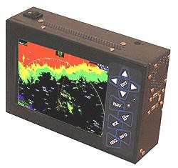
True Flight noted this week its
first Flight Cheetah system was sold 10 years ago Monday. The
Flight Cheetah was the first GPS Moving Map system to provide
satellite data link weather system for general aviation.
The satellite link that was used at the time was the ORBCOMM low
earth orbit satellite network. This network essentially operated as
a relatively low-bandwidth two-way connection in the sky, where the
pilot would request and receive weather. It also had the ability to
send and receive e-mails as well as send out position reports.
Several years later this feature was used by Erik Lindbergh while
flying across the Atlantic to send position reports and send and
receive e-mail communications.
About five years ago, the Flight Cheetah switched to the XM
weather system and was the first -- and still only, True Flight
notes -- company to use data link winds aloft data to automatically
show the pilot both the fastest and the most fuel-efficient flight
levels.
"I remember that first year that we started selling data link
weather systems. It was so foreign to pilots that it created many
unusual situations," recounted True Flight president Robert
Kalberer. "In that first year I think one story summed it up
best.
"One of our customers was flying IFR enroute from Pueblo, CO to
Wichita, KS and he could see about 100 miles west of Wichita that
there was a massive storm. He told the controller that there was no
way that he could get to Wichita on his current flight plan. When
the controller asked him how he could see what was 400 miles ahead
of him, he joked, and said he had his 400 mile radar turned on,
then explained he was receiving live weather through a
satellite.
"The controller was shocked that such a thing existed, and just
at that point, the pilot of a commercial airliner (wasting no time
to adopt this new technology) broke in and asked the pilot where
the storm front was. The commercial airliner pilot then requested
changes in his route to avoid the storm. Little did his passengers
know that they were being guided by a pilot in a Piper Comanche all
the way back from Pueblo, CO!"
More News
DETRESFA (Distress Phrase) The code word used to designate an emergency phase wherein there is reasonable certainty that an aircraft and its occupants are threatened by grave and i>[...]
"General aviation is at the forefront of developing and introducing innovative technologies that will transform the entire aviation industry..." Source: Kyle Martin, Vice President>[...]
Direct Straight line flight between two navigational aids, fixes, points, or any combination thereof. When used by pilots in describing off-airway routes, points defining direct ro>[...]
Aero Linx: Women in Corporate Aviation Women in Corporate Aviation support individuals seeking career advancement and professional development in the business aviation industry. Me>[...]
“We would like to thank the many volunteers that help throughout the year to pull off the event, as well as the several reviewers, judges, and SURVICE staff that provide team>[...]
 ANN's Daily Aero-Term (04.26.24): DETRESFA (Distress Phrase)

