Fri, Mar 18, 2011
Adds ADS-B In-Flight Weather, Terrain-Enhanced VFR Sectionals
And IFR Enroute Charts
Hilton Software has released an upgrade to its award-winning
WingX Pro7 iPad navigation system with the addition of ADS-B
in-flight weather, terrain-enhanced VFR sectionals and IFR low/high
enroute charts, and WAAS-enabled GPS capability. WingX Pro7 Version
5’s new Moving Map also adds pinch-to-zoom, extremely
high-resolution terrain, and TFRs.
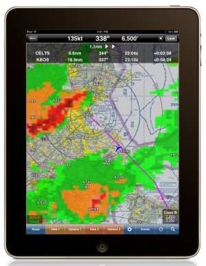
Further enhancements in the program released Wednesday include
the ability to display dual moving maps with overlaid terrain and
ADS-B NEXRAD including geo-referenced approach charts with
FAA-certified data for exceptional situational awareness.
“WingX Pro7’s Moving Map Engine has been
re-engineered to take full advantage of the iPad 2’s new
dual-core A5 processor," said Hilton Software founder Dr. Hilton
Goldstein. "We continually strive to be on the leading-edge of
mobile aviation technology and our latest release is a great
example of that. We are shifting the mobile paradigm away from
$3,000+ dedicated systems with high annual subscription
fees.”
“We have been listening to our users,” continues Dr.
Goldstein. “WingX Pro7 can print approach charts, rotate
charts, dim the Moving Map with a simple-to-use brightness control,
and find airports even if the user makes a typo in the airport name
or city name. We have also achieved exceptional database
compression to reduce download times and memory required. The most
requested feature after VFR and IFR enroute charts has been
in-flight weather. WingX Pro7’s ADS-B integration includes
NEXRAD, METARs, TAFs, PIREPs, NOTAM-Ds, AIRMETs, and more –
all in real-time while flying. An ADS-B receiver is required, but
there are no monthly charges – a big step in our quest to
make flying safer and more affordable.”
WingX Pro7 Version 5 is available now on the Apple App Store and
is iOS 4.3 and iPad 2 compatible. WingX Pro7 Version 5 is a free
update for registered users. WingX is available on iPhone, iPad and
iPad 2, iPod Touch, Android, BlackBerry, and Windows Mobile
devices.
More News
Airport Marking Aids Markings used on runway and taxiway surfaces to identify a specific runway, a runway threshold, a centerline, a hold line, etc. A runway should be marked in ac>[...]
"It is extremely difficult, if not impossible, for manned aircraft to see a drone while conducting crop-enhancing and other aerial applications at low altitudes and high speeds. We>[...]
Aero Linx: The Skyhawk Association The Skyhawk Association is a non-profit organization founded by former Skyhawk Pilots which is open to anyone with an affinity for the A-4 Skyhaw>[...]
“The T-54A benefits from an active Beechcraft King Air assembly line in Wichita, Kansas, where all required METS avionics and interior modifications are installed on the line>[...]
Aero Linx: Aerostar Owners Association The Association offers the Aerostar Owner a unique opportunity to tap an invaluable source of information concerning the care and feeding of >[...]
 ANN's Daily Aero-Term (04.28.24): Airport Marking Aids

