Adventure Pilot Adds Terrain, Active Alerting, Vertical Flight Planning | Aero-News Network
Aero-News Network
RSS icon RSS feed
podcast icon MP3 podcast
Subscribe Aero-News e-mail Newsletter Subscribe

Airborne Unlimited -- Most Recent Daily Episodes

Episode Date

Airborne-Monday

Airborne-Tuesday

Airborne-Wednesday Airborne-Thursday

Airborne-Friday

Airborne On YouTube

Airborne-Unlimited-04.29.24

Airborne-Unlimited-04.23.24

Airborne-Unlimited-04.24.24 Airborne-FltTraining-04.25.24

Airborne-Unlimited-04.26.24

Thu, Jul 12, 2012

Adventure Pilot Adds Terrain, Active Alerting, Vertical Flight Planning

Upgrades Pre-Loaded In New Version 7 Shipping Now

In the latest release of Adventure Pilot's iFly GPS software, users will find new features like Terrain/Obstructions, an Active Alerting System, Vertical Flight Planning, and numerous other enhancements. iFly GPS units are shipping from Adventure Pilot pre-loaded with these new features and current iFly GPS owners may now update to the Version 7 Software.

Terrain Mode affords the pilot a true perspective of nearby terrain. Terrain highlighting is transparent and can be enabled on the iFly’s numerous base maps, including Sectionals, Approach Plates, and Low-Enroute charts. Terrain and Obstruction alerts can be configured according to the pilot’s preference: Relaxed, Moderate, Strict, or Disabled.  Walter Boyd, president of Adventure Pilot, stated “Along with terrain highlighting, we added a panel that shows a close up of the vertical profile of upcoming terrain, obstructions, and airspaces. This instrument includes a projected climb-line, which gives the pilot an instant visual answer to the ‘am I going to make that?’ question.”

The iFly GPS—even though it’s a portable system—has extremely advanced collision avoidance capabilities. According to Boyd, “We based our alerting system on FAA-documented standards and best practices. The iFly GPS constantly monitors current and projected AGL, while tolerance levels automatically adjust with the flight phase. We even used FAA-defined audible call outs. Our goal was to maximize safety and minimize nuisance alerts. I believe we’ve achieved that goal—and more—with this release.”

A small Alert Window provides a centralized location for the management of all active alerts. Pilots may customize the window location to suit their needs. This new alert window actively changes based on the most relevant alert and can be expanded to view more information on the active alert item.

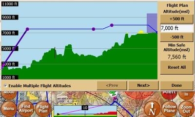
The Version 7 Software Update also adds a revolutionary Vertical Flight Planning feature. This feature provides the ability to reference terrain and customize the flight plan relative to terrain, airspaces, aircraft performance, and even winds aloft. "This new Vertical Flight Planning feature proves once again that iFly GPS is leading innovation in the Portable Aviation GPS category by offering pilots an intuitive and revolutionary flight planning tool,” said Boyd.

Other enhancements to the iFly GPS User Interface include a PDF viewer, an improved flight timer, new location icons, revised menus, plus faster performance and stability. Adventure Pilot also released a new application for Windows, called iFly Connect, which allows iFly GPS owners an even simpler and faster way of updating their GPS with the latest software and data.

(Image provded by Adventure Pilot)

FMI: www.iFlyGPS.com

Advertisement

More News

Unfortunate... ANN/SportPlane Resource Guide Adds To Cautionary Advisories

The Industry Continues to be Rocked By Some Questionable Operations Recent investigations and a great deal of data has resulted in ANN’s SportPlane Resource Guide’s rep>[...]

ANN FAQ: Turn On Post Notifications

Make Sure You NEVER Miss A New Story From Aero-News Network Do you ever feel like you never see posts from a certain person or page on Facebook or Instagram? Here’s how you c>[...]

ANN's Daily Aero-Term (04.29.24): Visual Approach Slope Indicator (VASI)

Visual Approach Slope Indicator (VASI) An airport lighting facility providing vertical visual approach slope guidance to aircraft during approach to landing by radiating a directio>[...]

ANN's Daily Aero-Term (04.28.24): Airport Marking Aids

Airport Marking Aids Markings used on runway and taxiway surfaces to identify a specific runway, a runway threshold, a centerline, a hold line, etc. A runway should be marked in ac>[...]

ANN's Daily Aero-Linx (04.28.24)

Aero Linx: The Skyhawk Association The Skyhawk Association is a non-profit organization founded by former Skyhawk Pilots which is open to anyone with an affinity for the A-4 Skyhaw>[...]

blog comments powered by Disqus


Advertisement

Advertisement

Podcasts

Advertisement

© 2007 - 2024 Web Development & Design by Pauli Systems, LC