Stones Bear Evidence Of An Environment That Was At One Time Wet
NASA's Mars rover Curiosity has resumed a trek of many months toward its mountain-slope destination, Mount Sharp. The rover used instruments on its arm last week to inspect rocks at its first waypoint along the route inside Gale Crater.
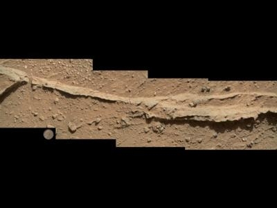
The location, originally chosen on the basis of images taken from NASA's Mars Reconnaissance Orbiter, paid off with investigation of targets that bear evidence of ancient wet environments. "We examined pebbly sandstone deposited by water flowing over the surface, and veins or fractures in the rock," said Dawn Sumner of University of California, Davis, a Curiosity science team member with a leadership role in planning the stop. "We know the veins are younger than the sandstone because they cut through it, but they appear to be filled with grains like the sandstone."
This Waypoint 1 site at an outcrop called "Darwin" is the first of up to five waypoint stops planned along the route of about 5.3 miles between the "Glenelg" area, where Curiosity worked for the first half of 2013, and an entry point to the lower slope of Mount Sharp, the mission's main destination. It is about one-fifth of the way along the route. The rover departed Waypoint 1 on Sept. 22 with a westward drive of about 75 feet.
Curiosity's science team planned the waypoints to collect information about the geology between Glenelg and Mount Sharp. Researchers want to understand relationships between what the mission already discovered at Glenelg and what it may find in the multiple layers of Mount Sharp. Analysis of drilled samples from veined "Yellowknife Bay" rocks in the Glenelg area provided evidence for a past lakebed environment with conditions favorable for microbial life. That means the mission has fulfilled its principal science goal.
"We want to understand the history of water in Gale Crater," Sumner said. "Did the water flow that deposited the pebbly sandstone at Waypoint 1 occur at about the same time as the water flow at Yellowknife Bay? If the same fluid flow produced the veins here and the veins at Yellowknife Bay, you would expect the veins to have the same composition. We see that the veins are different, so we know the history is complicated. We use these observations to piece together the long-term history."
Researchers set the top priority for the Waypoint 1 stop to be examination of a conglomerate rock outcrop, such as the pebbly sandstone. The veins were a bonus. "As often happens, the closer we get, the more is revealed," said Kenneth Williford of NASA's Jet Propulsion Laboratory, Pasadena, Calif., a Curiosity science team member active in planning use of the rover's arm. The first specific location at Waypoint 1 for parking the rover and using the instruments on its arm was selected because images taken from nearly a football-field's length away showed outcrops that looked like conglomerate. Once Curiosity approached that location, new images showed the veins, so a second location for use of the arm was added to the plan.
The rover spent one day using its arm at the first location and three more using its arm from the second location. On all four of these "contact-science" days, the investigations employed two instruments that are mounted in the turret at the end of the arm: the Alpha Particle X-ray Spectrometer, which identifies chemical elements present in a target, and the Mars Hand Lens Imager, which shows targets' textures, shapes and colors.
Another device on the turret still holds some powder from a rock that Curiosity drilled into for sample collection at Yellowknife Bay four months ago. The laboratory instruments inside the rover have already analyzed portions from this sample, but researchers have options of many different instrument settings for doing further analyses. In weeks ahead, additional portions from the sieved powder being held in the arm may be delivered for those analyses. The powder is a precious scientific resource, but it also presents a special challenge for use of the spectrometer and camera on the turret. "We don't want to put the turret in a position that gets the sample material onto the back side of the sieve, because that could clog pores in the sieve," said JPL's Matt Robinson, lead engineer for Curiosity's robotic arm operations. "We have to consider the orientation of the turret during all of the moves for reaching the target, not just its orientation at the target."
Despite this challenge, the team used the arm instruments intensively at Waypoint 1. On Sept. 19, the rover examined five targets with the spectrometer and camera on the arm. The next day, from the same location, it examined three more. The team did leave some potential targets unexamined, to hasten back on the drive to Mount Sharp, as planned.
"There's a trade-off," Williford said, "between wanting to reach Mount Sharp as soon as we can and wanting to chew on rocks all along the way. Our team of more than 450 scientists has set the priority on getting to Mount Sharp, with these few brief waypoint stops."
(Images provided by NASA)
 Unfortunate... ANN/SportPlane Resource Guide Adds To Cautionary Advisories

