Hurricane Hunters Track Ike As Storm Moves Toward Texas | Aero-News Network
Aero-News Network
RSS icon RSS feed
podcast icon MP3 podcast
Subscribe Aero-News e-mail Newsletter Subscribe

Airborne Unlimited -- Most Recent Daily Episodes

Episode Date

Airborne-Monday

Airborne-Tuesday

Airborne-Wednesday Airborne-Thursday

Airborne-Friday

Airborne On YouTube

Airborne-Unlimited-04.29.24

Airborne-Unlimited-04.23.24

Airborne-Unlimited-04.24.24 Airborne-FltTraining-04.25.24

Airborne-Unlimited-04.26.24

Fri, Sep 12, 2008

Hurricane Hunters Track Ike As Storm Moves Toward Texas

Expected To Hit Galveston Saturday Morning

Barreling toward the Texas coast, Hurricane Ike is gaining strength as millions of residents in the storm's forecast path evacuate in expectation of an overnight landfall Saturday morning.

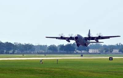
As Ike entered the Gulf of Mexico after battering Cuba this week, a WC-130J Hurricane Hunter crew based at Keesler AFB in Mississippi flew into the storm, pinpointing the center and sending flight-level and surface-level readings back to the National Hurricane Center via satellite.

Citizen-airmen of the 53rd Weather Reconnaissance Squadron, charged with flying directly into the eye of nature's most powerful storms, continue around-the-clock flights into Ike giving forecasters at the NHC the best possible data.

Hurricane Ike, now a Category 2 on the Safir-Simpson Scale, is expected to intensify before making landfall early tomorrow. The storm already has killed 80 people in the Caribbean and took a significant toll on parts of Cuba, especially areas previously affected by Hurricane Gustav.

As of 8:00 am EDT Friday, Ike's center was about 365 miles east of Corpus Christi, TX and about 230 miles southeast of Galveston, according to a National Hurricane Center advisory.

Maximum sustained winds were at 105 mph, but the storm is expected to strengthen before it moves ashore, and is forecast to be a major hurricane by then, the advisory said. The storm is moving west-northwest at 13 mph. A turn to the northwest is expected Friday, forecasters said, with a turn toward the north expected Saturday.

Residents in the projected path and near those regions are urged to pay close attention to government and news sources in their areas for critical watches and warnings.

(Aero-News thanks Air Force Tech. Sgt. James B. Pritchett, 403rd Wing Public Affairs Office)

FMI: www.keesler.af.mil, www.noaa.gov

Advertisement

More News

ANN's Daily Aero-Term (04.26.24): DETRESFA (Distress Phrase)

DETRESFA (Distress Phrase) The code word used to designate an emergency phase wherein there is reasonable certainty that an aircraft and its occupants are threatened by grave and i>[...]

Aero-News: Quote of the Day (04.26.24)

"General aviation is at the forefront of developing and introducing innovative technologies that will transform the entire aviation industry..." Source: Kyle Martin, Vice President>[...]

ANN's Daily Aero-Term (04.27.24): Direct

Direct Straight line flight between two navigational aids, fixes, points, or any combination thereof. When used by pilots in describing off-airway routes, points defining direct ro>[...]

ANN's Daily Aero-Linx (04.27.24)

Aero Linx: Women in Corporate Aviation Women in Corporate Aviation support individuals seeking career advancement and professional development in the business aviation industry. Me>[...]

Aero-News: Quote of the Day (04.27.24)

“We would like to thank the many volunteers that help throughout the year to pull off the event, as well as the several reviewers, judges, and SURVICE staff that provide team>[...]

blog comments powered by Disqus


Advertisement

Advertisement

Podcasts

Advertisement

© 2007 - 2024 Web Development & Design by Pauli Systems, LC