iPhone App Released For ForeFlight Mobile | Aero-News Network
Aero-News Network
RSS icon RSS feed
podcast icon MP3 podcast
Subscribe Aero-News e-mail Newsletter Subscribe

Airborne Unlimited -- Most Recent Daily Episodes

Episode Date

Airborne-Monday

Airborne-Tuesday

Airborne-Wednesday Airborne-Thursday

Airborne-Friday

Airborne On YouTube

Airborne-Unlimited-05.20.24

Airborne-NextGen-05.21.24

Airborne-Unlimited-05.15.24 Airborne-AffordableFlyers-05.16.24

Airborne-Unlimited-05.17.24

Thu, Dec 17, 2009

iPhone App Released For ForeFlight Mobile

Features Useful For Pilots From Student To ATP

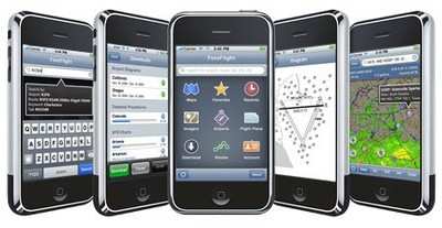
It seems like every time we turn around, the device that we used to know as a cellular phone becomes more integrated into our lives. ForeFlight took the wraps off ForeFlight Mobile 3 for iPhone and iPod on Wednesday, a flight planning tool that ForeFlight says will allow pilots to visualize and plan flights faster than ever before.

ForeFlight says they have improved the weather presentation technology, which increases pre-flight situational awareness and confidence, and makes pilots more productive. The v3.0 software has a re-designed user interface and features that will be useful for pilots ranging form student to ATP.

Among the new features in ForeFlight Mobile 3:

  • Brand new Slip Maps with slideable, zoomable maps for weather and charts.
  • Flight routes displayed over animated, QICP-certified  HD NEXRAD and satellite.
  • Full screen, downloadable, GPS-integrated moving map VFR sectionals.
  • Full screen, downloadable, GPS-integrated moving map IFR high and low enroute charts.
  • One-tap Intelligent Flight Briefings via DUATS with smart refresh, briefing email confirmations, and archival on ForeFlight servers for extra assurance.
  • Redesigned route planning with NAVAID support and wind-corrected flight plans.
  • Redesigned airport interface for faster access to airports, weather, and imagery.
  • Global airport database with the best information from the FAA, AOPA Airport Directory, and Universal Weather and Aviation’s UVTripPlanner airport directories.
  • Redesigned NOTAMs organized by airport, TFRs, and regional ARTCC.
  • Local storage of all airport procedures, charts, briefings, and flight plans so you can view them offline.

ForeFlight Mobile provides color-coded METARs, TAFs, winds aloft, infrared satellite, NOTAMs, graphical TFRs, FBOs, and flight plan filing.

Special introductory pricing is available for new subscribers and upgraders.

FMI: www.foreflight.com/mobile

Advertisement

More News

Samson Sky Hits the Wind Tunnel

Improvements Stack as Brand Readies for Mass Production Samson Sky updated followers on its flying car progress, describing some of the travails of the wind tunnel as they get clos>[...]

ANN's Daily Aero-Term (05.22.24): LAHSO

LAHSO An acronym for “Land and Hold Short Operation.” These operations include landing and holding short of an intersecting runway, a taxiway, a predetermined point, or>[...]

Aero-FAQ: Dave Juwel's Aviation Marketing Stories -- ITBOA BNITBOB

Dave Juwel's Aviation Marketing Stories ITBOA BNITBOB ... what does that mean? It's not gibberish, it's a lengthy acronym for "In The Business Of Aviation ... But Not In The Busine>[...]

ANN's Daily Aero-Linx (05.19.24)

Aero Linx: Space Medicine Association (SMA) The Space Medicine Branch was founded in 1951 as the first constituent organization of the Aerospace Medical Association (AsMA). In 2006>[...]

ANN's Daily Aero-Term (05.19.24): Back-Taxi

Back-Taxi A term used by air traffic controllers to taxi an aircraft on the runway opposite to the traffic flow. The aircraft may be instructed to back-taxi to the beginning of the>[...]

blog comments powered by Disqus


Advertisement

Advertisement

Podcasts

Advertisement

© 2007 - 2024 Web Development & Design by Pauli Systems, LC