Thu, Feb 04, 2010
Scientists Hope To Be Able To Measure Tectonic Plate
Movements
JPL's Uninhabited Aerial Vehicle Synthetic Aperture Radar
(UAVSAR) captured this false-color composite image of the city of
Port-au-Prince, Haiti, and the surrounding region on Jan. 27, 2010.
Port-au-Prince is visible near the center of the image. The large
dark line running east-west near the city is the main airport.
UAVSAR left NASA's Dryden Flight Research Center in Edwards, CA,
January 25, aboard a modified NASA Gulfstream III aircraft on a
three-week campaign that will also take it to Central America.
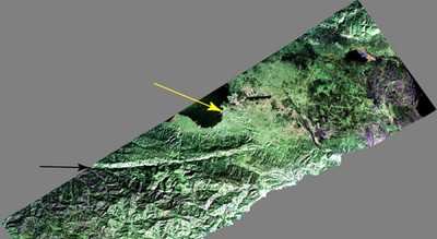
Photo Courtesy JPL
Shortly before 1700 local time on January 12,a magnitude 7.0
earthquake struck southern Haiti. The earthquake's epicenter was
about 25 kilometers (15 miles) west-southwest of Port-au-Prince,
close to the west (left) edge of this image (yellow arrow). The
large linear east-west valley in the mountains south of the city is
the location of the major active fault zone responsible for the
earthquake: the Enriquillo-Plantain Garden fault (black arrow). The
fault extends from the western tip of Haiti past Port-au-Prince
into the Dominican Republic to the east of this image. Historical
records show that the southern part of Haiti was struck by a series
of large earthquakes in the 1700s, and geologists believe those
were also caused by ruptures on this fault zone.
Satellite interferometric synthetic aperture radar measurements
show that the January 12 earthquake ruptured a segment of the fault
extending from the epicenter westward over a length of about 40
kilometers (25 miles), leaving the section of the fault in this
image unruptured. The earthquake has increased the stress on this
eastern section of the fault south of Port-au-Prince and the
section west of the rupture. This has significantly increased the
risk of a future earthquake, according to a recent report by the
U.S. Geological Survey.
This image will be combined with other images of the same area
to be acquired later this month and in the future in order to
measure the motion of Earth's surface during the time between
images using a technique called interferometry.The interferometric
measurements will allow scientists to study the pressures building
up and being released on the fault at depth.
More News
Aviation Governance Secured...At Least For a While The National Business Aviation Association similarly applauded the passage of the FAA's recent reauthorization, contentedly recou>[...]
Emphasis On Growing The Future of Aviation Through Concentration on 'AFFORDABLE FLYERS' It's been a number of years since the Latest Edition of Jim Campbell's HUGE SportPlane Resou>[...]
Amazilia Aerospace GmbH, Develops Digital Flight Control, Flight Guidance And Vehicle Management Systems Textron eAviation has acquired substantially all the assets of Amazilia Aer>[...]
Honeywell's Primus Brings New Tools and Niceties for Hawker Operators Hawker 4000 business jet operators have a new installation on the table, now that the FAA has granted an STC f>[...]
Company Celebrates Niche-but-Important Advancement in Industry Standards Echodyne has announced full integration of its proprietary 'EchoFlight' radar into the e American Aerospace>[...]
 Bolen Gives Congress a Rare Thumbs-Up

