Rogue Army Drone Flys 630 Miles After Losing Comm Link | Aero-News Network
Aero-News Network
RSS icon RSS feed
podcast icon MP3 podcast
Subscribe Aero-News e-mail Newsletter Subscribe

Airborne Unlimited -- Most Recent Daily Episodes

Episode Date

Airborne-Monday

Airborne-Tuesday

Airborne-Wednesday Airborne-Thursday

Airborne-Friday

Airborne On YouTube

Airborne-Unlimited-05.06.24

Airborne-NextGen-05.07.24

Airborne-Unlimited-05.08.24 Airborne-FlightTraining-05.09.24

Airborne-Unlimited-05.10.24

Mon, Mar 06, 2017

Rogue Army Drone Flys 630 Miles After Losing Comm Link

Aircraft Was Located 10 Days Later In A Tree Near Denver, CO

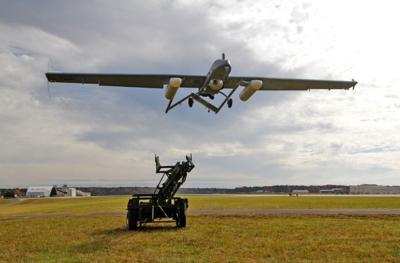
A U.S. Army SQ-7Bv2 drone launched in southern Arizona on January 31 lost lost connection with its controllers shortly after becoming airborne, and was not heard from again until it was discovered in pieces in a tree near Denver, CO 10 days later.

Stars and Stripes reports that the Shadow Drone was deployed as part of a training mission at Fort Huachuca in Arizona by soldiers from the 2nd Stryker Brigade of the 7th Infantry Division at Joint Base Lewis-McChord in Washington, according to Lt. Col. Fredrick Williams, a division spokesman.

Tanja Linton, a spokeswoman for the Fort Huachuca, said that the aircraft flew the entire 630 miles without the benefit of positive control from an operator.

What is not know is how the aircraft, which has a published range of 77 miles, managed to fly nearly eight times that distance. Army Aviation spokesman Paul Stevenson told Stars and Stripes that the 450-pound aircraft with a 20-foot wingspan normally operates autonomously using a pre-set bearing, altitude and wind speed. The crew normally consists of a flight operator and a payload operator, who controls the onboard camera.

While Stevenson would not reveal the actual range of the aircraft, the 77-mile range is the limit of the link of the ground control station with the aircraft. It can fly much further than 77 miles in a circular pattern, he said.

Paul Scharre, a former unmanned system policy official at the Pentagon and director of the Future of Warfare Initiative at the Center for a New American Security, said that link-loss is not uncommon, but is accounted for in the aircraft's design.

The aircraft had to fly at altitudes of at least 12,000 feet to clear mountains along the route it took. It was found by a hiker in the tree in Evergreen, CO missing a wing.

Textron, the manufacturer of the aircraft, declined to comment about the Shadow's capabilities or confirm any discussions with the Army about safety or legal issues with such a wayward aircraft.

(U.S. Army file image)

FMI: Full Article

Advertisement

More News

Airborne-Flight Training 05.09.24: ERAU at AIAA, LIFT Diamond Buy, Epic A&P

Also: Vertical Flight Society, NBAA Maintenance Conference, GA Honored, AMT Scholarship For the first time, students from Embry-Riddle’s Daytona Beach, Florida, campus took t>[...]

ANN's Daily Aero-Term (05.07.24): Hazardous Weather Information

Hazardous Weather Information Summary of significant meteorological information (SIGMET/WS), convective significant meteorological information (convective SIGMET/WST), urgent pilot>[...]

Aero-News: Quote of the Day (05.07.24)

"The need for innovation at speed and scale is greater than ever. The X-62A VISTA is a crucial platform in our efforts to develop, test and integrate AI, as well as to establish AI>[...]

NTSB Final Report: Cessna 150

(FAA) Inspector Observed That Both Fuel Tanks Were Intact And That Only A Minimal Amount Of Fuel Remained In Each Analysis: According to the pilot, approximately 8 miles from the d>[...]

Aero-News: Quote of the Day (05.08.24)

“Pyka’s Pelican Cargo is unlike any other UAS solution on the market for contested logistics. We assessed a number of leading capabilities and concluded that the Pelica>[...]

blog comments powered by Disqus


Advertisement

Advertisement

Podcasts

Advertisement

© 2007 - 2024 Web Development & Design by Pauli Systems, LC