RedTail LiDAR Systems Unveils Innovative 3D Mapping Solution | Aero-News Network
Aero-News Network
RSS icon RSS feed
podcast icon MP3 podcast
Subscribe Aero-News e-mail Newsletter Subscribe

Airborne Unlimited -- Most Recent Daily Episodes

Episode Date

Airborne-Monday

Airborne-Tuesday

Airborne-Wednesday Airborne-Thursday

Airborne-Friday

Airborne On YouTube

Airborne-Unlimited-04.29.24

Airborne-NextGen-04.30.24

Airborne-Unlimited-05.01.24 Airborne-AffordableFlyers--05.02.24

Airborne-Unlimited-05.03.24

Fri, Oct 25, 2019

RedTail LiDAR Systems Unveils Innovative 3D Mapping Solution

RTL-400 Introduced At Commercial UAV EXPO As High-Resolution LiDAR System For Small Drones

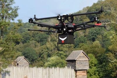
RedTail LiDAR Systems, a division of 4D Tech Solutions, Inc, will introduce the RTL-400 LiDAR mapping system at the Commercial UAV EXPO on October 28th. The RTL-400 was designed specifically to provide high-resolution 3D images of objects on the ground from small drones flying at an altitude up to 400 feet.

Developed with technology licensed from the U.S. Army Research Laboratory (ARL), the RTL-400 provides unique scanning capabilities for a wide range of applications – from precision agriculture to construction site monitoring and management.

The RTL-400 incorporates an innovative microelectromechanical system (MEMS) mirror-based laser scanner that rapidly and evenly distributes laser pulses to the ground, moving side-to-side 400 times each second. This rapid line scan rate, coupled with a laser pulse rate of up to 400,000 pulses per second, yields point clouds that are unprecedented in resolution and density.

Unlike other LiDAR systems, the RTL-400 can be operated in two scanning modes. In addition to the line scan mode, the RTL-400 offers a 30 x 30-degree raster scan mode for "stand and stare" missions. The scanning mode can be selected on the fly, providing drone operators unmatched operational flexibility when planning and flying their missions.

"We are very excited to introduce RedTail LiDAR System's RTL-400. This product has been optimized for use on small drones, providing high-quality point clouds to meet the needs found in the numerous fields where LiDAR is used," said Brad DeRoos, president and CEO of RedTail LiDAR Systems.

Meet the RedTail LiDAR Systems team at the Commercial UAV EXPO in Las Vegas, October 28-30.

(Images provided with RedTail LiDAR Systems news release)

FMI: www.redtaillidar.com

Advertisement

More News

ANN's Daily Aero-Linx (05.02.24)

Aero Linx: Model Aeronautical Association of Australia MAAA clubs are about fun flying, camaraderie and community. For over 75 years, the MAAA has been Australia’s largest fl>[...]

ANN's Daily Aero-Term (05.02.24): Touchdown Zone Lighting

Touchdown Zone Lighting Two rows of transverse light bars located symmetrically about the runway centerline normally at 100 foot intervals. The basic system extends 3,000 feet alon>[...]

Aero-News: Quote of the Day (05.02.24)

“Discovery and innovation are central to our mission at Virgin Galactic. We’re excited to build on our successful record of facilitating scientific experiments in subor>[...]

ANN FAQ: Contributing To Aero-TV

How To Get A Story On Aero-TV News/Feature Programming How do I submit a story idea or lead to Aero-TV? If you would like to submit a story idea or lead, please contact Jim Campbel>[...]

NTSB Final Report: Cirrus Design Corp SR20

Student Pilot Reported That During Rotation, “All Of A Sudden The Back Of The Plane Kicked To The Right..." Analysis: The student pilot reported that during rotation, “>[...]

blog comments powered by Disqus


Advertisement

Advertisement

Podcasts

Advertisement

© 2007 - 2024 Web Development & Design by Pauli Systems, LC