 Aero-News learned
Wednesday the Oregon Wing of the Civil Air Patrol and the United
States Geological Survey, will participate in a six-state seismic
survey event the weekend of August 25-27.
Aero-News learned
Wednesday the Oregon Wing of the Civil Air Patrol and the United
States Geological Survey, will participate in a six-state seismic
survey event the weekend of August 25-27.
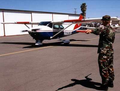
Oregon's CAP will operate out of Willamette Aviation at the
Aurora State Airport with five aircraft, and up to 50 personnel.
Other CAP wings participating in the exercise will hail from
California, Alaska, Hawaii, and Nevada.
Oregon CAP will be transporting simulated USGS personnel from
Seattle to Redding, and will also be conducting photo and
reconnaissance flights in both Washington and Oregon. The exercise
began August 16th with over 22 flights in Oregon to date with
aircraft operating out of bases in Salem, Aurora,Bend,Redmond and
Medford.
The seismic survey event, involving volcanic as well as
earthquake activity, will involve over 75 aircraft and
corresponding air crews, ground support personnel and
communications specialists, will be part of a national program to
better understand and respond to local seismic danger spots and
practice emergency response to a major seismic event in the Pacific
Northwest.
Oregon CAP will be utilizing its Satellite Digital Imaging
System to provide real-time aerial digital photography
capabilities.
"While this exercise is simulated, actual targets are based on
real historical events and research that have identified points of
specific interest" said CAP spokesman Lt.Col. Thomas Traver, public
affairs officer for the Oregon Wing of the CAP. "The photos taken
are of targets identified by the USGS and will be actually used by
the USGS research team to further their understanding and knowledge
of local geology as it pertains to potential future seismic
events." he added.
"This exercise will be used not only to gather information for
the USGS, but will also serve to train new and existing air crews
and ground personnel in disaster response and to effectively
utilize new technology in disaster triage, rescue and recovery
operations" said Traver.
According to the USGS, volcanoes are not randomly distributed
over the Earth's surface. Most are concentrated on the edges of
continents, along island chains, or beneath the sea forming long
mountain ranges. More than half of the world's active volcanoes
above sea level encircle the Pacific Ocean to form the
circum-Pacific "Ring of Fire.".
There are more than 500 active volcanoes (those that have
erupted at least once within recorded history) in the world -- 50
of which are in the United States (Hawaii, Alaska, Washington,
Oregon, and California) -- although many more may be hidden under
the seas.
If high enough in magnitude, earthquakes will cause Tsunamis.
Between June 30 and July 11, 2006, there were sixteen earthquakes
on the western coastline of Alaska between 4.4 and 5.9 magnitude,
none of which was strong enough to create a tsunami.
As of May 30, 2006 there were 29 Tsunami Ready sites in seven
states, with four on the west coast of Alaska, Washington, Oregon,
and California
 ANN's Daily Aero-Term (04.28.24): Airport Marking Aids

