Airplane Impacted Guy Wires Supporting A Television Tower Resulting In One Fatal Injury
The NTSB has issued its factual report from an accident involving a Piper PA46 500TP aircraft which struck a guy wire supporting a television tower near the Lubbock, TX airport in February 2015. The sole occupant of the aircraft was fatally injured in the accident.
According to the report, On February 4, 2015, at 1930 central standard time, the aircraft collided with a television (TV) tower guy wire and terrain about 7 miles south of the Lubbock Preston Smith International Airport (LBB), Lubbock, Texas. The pilot, who was the sole occupant, was fatally injured and the airplane was destroyed. The airplane was registered to Deadalus Air LLC, and operated by a private individual under the provisions of 14 Code of Federal Regulations Part 91 as a personal flight. Instrument meteorological conditions prevailed at the time of the accident and an instrument flight rules (IFR) flight plan was filed en route. The airplane departed the Cavern City Air Terminal (CNM), Carlsbad, New Mexico about 1830 and was en route to LBB.
A review of the LBB air traffic control transcripts and radar data revealed the pilot was executing the RNAV (GPS) Y instrument approach to runway 35L. The controller canceled the pilot's approach clearance for spacing and issued a heading change off of the approach course. The airplane started a left climbing turn and then descended; the airplane was no longer visible on the radar display and contact with the pilot was lost. Additional attempts to contact the pilot were unsuccessful.
A witness located in a parking lot next to the TV tower stated that he heard the accident airplane overhead and it sounded like the airplane's engine was operating. He looked up and saw a large flash of light that filled his field of view. He observed the TV tower's red beacon lights disappear and then the tower collapsed on top of itself. He described the weather as cold, very low clouds, and no precipitation.
Surveillance videos from two different locations showed the airplane in a steep descent headed toward the tower. The airplane passed behind the tower and then multiple large flashes of light were observed.
The 60-year-old pilot held a private pilot certificate with single engine and multi-engine land airplane and instrument airplane ratings. According to his training records and incomplete pilot logbook entries, as of December 31, 2013, he had accumulated 1,073 total hours, 117 of which were at night. He had accumulated 50 hours in actual IFR conditions and 44 hours in simulated IFR. The pilot's complete background in the accident airplane could not be determined because the logbook entries were incomplete.
On March 29, 2013, the pilot was issued an FAA third class medical certificate with the limitation that he must have available glasses for near vision. On the application for the medical certificate, he reported his total flight experience to be 2,067 hours and 45.5 hours in the last 6 months.
On December 31, 2013, the pilot completed a biennial flight review (BFR). During the BFR, the pilot satisfactorily completed an instrument proficiency check and was found proficient in the operation of a pressurized aircraft.
The six-seat, low wing, retractable landing gear airplane with cabin pressurization capability, was manufactured in 2001. The airplane was powered by a Pratt & Whitney Canada PT6A-42A reverse flow, free turbine engine. The engine drove a four blade, metal, constant speed propeller with reversing and full feathering capabilities. Each propeller blade was equipped with an electric deice boot.
On December 22, 2014, the airframe, engine and propeller were inspected in accordance with an annual inspection and were determined to be in airworthy condition.
On December 22, 2011, the airplane was retrofitted with pilot and co-pilot Garmin G500 flight displays, No. 1 and No. 2 Garmin GTN75O touchscreen navigators, GMA35 remote audio control, GTX33 remote mode 'S' transponder, GDL69A XM weather data receiver with XM Radio, and an upgraded S-Tec 1500 autopilot computer for wide area augmentation system (WAAS).
A fuel receipt found in the airplane, dated February 4, 2015 at 14:23:58, indicated that the airplane had been fueled with 35 gallons of Jet A fuel.
A fuel burn calculation for the entire flight was estimated to be 35.5 gallons.
At 1853, the weather observation station for LBB, located 10 miles north of the accident site, reported wind from 030° at 21 knots gusting to 31 knots, 8 miles visibility, overcast cloud layer at 800 ft above ground level (agl), temperature 28° F, dew point 25° F, and altimeter setting 30.24 inches of mercury; peak wind from 20° at 34 knots and occasional blowing dust.
At 1947, a special weather observation for LBB reported wind from 040° at 18 knots gusting to 27 knots, 7 miles visibility, overcast cloud layer at 700 ft agl, temperature 28° F, dew point 25° F, and altimeter setting 30.28 inches of mercury; peak wind from 030° at 31 knots.
Prior to the accident, a pilot report (PIREP) was issued for moderate rime ice at 5,200 ft mean sea level (msl) / 1,918 ft agl about 10 miles south of the airport. The pilot acknowledged receipt of this report.
Lockheed Martin Flight Services had no history of contact with the accident pilot on February 4, 2015.
A chronological summary of communications with the Lubbock Air Traffic Control Tower (LBB ATCT).
1907:20 The accident pilot first contacted LBB reporting an altitude of 16,700 ft and descending to 14,000 ft. The LBB radar controller instructed the pilot to descend at his discretion to 7,000 ft and confirmed the pilot's receipt of the current ATIS information "Whiskey."
1907:58 The LBB radar controller informed the pilot that a regional jet had reported moderate rime icing at 5,000 feet approximately 10 miles south of the airfield, and the pilot acknowledged with "okay, I'll be looking."
1909:32 The pilot requested the current ceiling and the radar controller informed him that bases had been previously reported 3,900 feet. The pilot acknowledged stating that it was better than "his weather information" which had indicated an 800 ft ceiling. The controller then explained that the bases were reported in msl, which would make the ceiling approximately 800 feet agl. The pilot acknowledged, and stated his information was in agreement.
1912:23 A position relief briefing took place on the LBB radar controller in which all pertinent information was passed to the relieving radar controller to include current ATIS information, PIREP information, approach in use, and traffic information including N301D who had been cleared to 7,000 ft.
1914:19 The radar controller announced on the recorded line that the required controller two minute overlap after relief was complete.
1918:02 The radar controller asked the pilot what type of approach was being requested and the pilot stated that he wanted the RNAV RWY 35L, but that he was having a little trouble getting his instruments set up and wanted to circle until he could get things worked out. The radar controller then asked the pilot to advise once he knew what he wanted to do.
1918:41 The radar controller instructed the pilot to maintain at or above 8,000 ft, that he could continue on his present heading, and told him he would just box him back in once he had figured out his instrument issues. The pilot acknowledged with a correct read back.
1921:24 The pilot stated that he wanted to turn south direct to ZOVOC for the RNAV RWY 35L. The radar controller instructed him to turn right to a 160 heading and descend and maintain 7,000 ft. The pilot acknowledged the turn, but not the descent.
1922:20 The radar controller asked the pilot for his current altitude, and the pilot stated that he was descending through 9,340 ft to 7,000 ft.
1923:00 The radar controller asked the pilot how many flying miles he would need to make his descent to the airport. The pilot responded that he just wanted to continue his present direction for a bit further and then he could start his turn back to the west and continue on his flight plan to ZOVOC.
1923:17 The radar controller instructed the pilot to turn right to a 220 heading. The pilot acknowledged with a correct read back.
1924:39 The radar controller instructed the pilot to turn right to a 260 heading. The pilot acknowledged with a correct read back.
1925:19 The radar controller cleared the flight for the RNAV Y RWY 35L approach and instructed the pilot to cross ZOVOC at or above 6,000 ft. The pilot acknowledged the "direct ZOVOC", but had some trouble understanding the remainder of the controller's instructions. After some clarification, the accident pilot acknowledged the approach clearance and altitude crossing restriction.
1926:13 The tower controller called down and informed the radar controller that he might have to cancel N301D's approach because he had another inbound (N319ME) that had remained faster than he expected, and had also requested to circle to another runway and the controller would need room to do that. The tower controller further stated that N319ME was "flying crazy…", so the radar controller stated that he would just take N301D off the approach and bring him back around for another.
1929:29 The radar controller cancelled N301D's approach clearance and instructed the pilot to climb to 7,000 ft and fly a heading of 275 degrees for re-sequencing. The pilot acknowledged and then confirmed the turn which the controller amended to 270 degrees.
1929:56 The last recorded transmission from the accident pilot was a read back of the 270 heading assignment.
1930:50 After a couple of attempts to contact the accident pilot with no response, the radar controller explained to the local controller that they had just experienced a "power spike" and that he was going to attempt contact via the portable radio in the event the power spike had affected their ground based communication equipment.
1932 LBB requested another aircraft on the frequency to attempt to contact the accident pilot. No response was received.
1934 The tower controller called the radar controller and advised him there had been a plane crash.
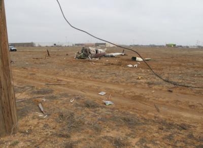
The accident site was located in a series of large fields lined with fences and dirt paths. The main wreckage was located at latitude 33°32'36.13"N, longitude 101°50'8.10"W, at an elevation of 3,200 ft msl. A path of debris extended southwest from a local news building at 5600 Avenue A, Lubbock, Texas, to the main wreckage; the debris path was on a heading of 040 degrees and was about 800 ft in length.
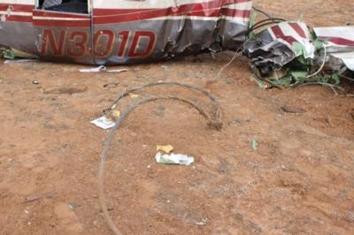
On the southeast corner of the news building stood a partially collapsed red and white TV tower, most of which had collapsed on the ground. The tower's guy wires were strewn on the ground near the tower. However, one guy wire was extended toward the main wreckage and remained connected to its base on the ground. The end of the guy wire was found next to the fuselage and exhibited signatures of tension overload.
Several pieces of airplane debris were found near the base of the tower in the direction of the main wreckage. The left elevator surface was detached and came to rest in the debris path about 400 ft from the main wreckage. The right wing, less its aileron, was right side up in the debris path and located about 260 ft from the main wreckage. A piece of the engine cowling was in the debris path about 185 ft from the main wreckage. The entire left wing was in the debris path about 110 ft from the main wreckage.
Two parallel sets of power lines ran north-south across the debris path about 50 west of the main wreckage. One wooden power pole was broken near the top and its associated power lines and equipment laid on the ground. Several other power lines were separated in tension overload and laid on the ground in the direction of the main wreckage.
The fuselage came to rest upright on a general heading of west. The cockpit area was opened, twisted and distorted to the left.
The engine came to rest about 50 ft from the cockpit area to the east. A propeller blade tip separated and exhibited scoring consistent with contact with a metal wire. The propeller nose cone displayed striations consistent with a large gauge wire similar to the downed guy wire.
Garmin G500 flight displays and a Garmin GTN750 were installed on the airplane. Several SD data cards were found in the Garmin devices and in the wreckage near the cockpit. The installed Garmin systems did not have flight data recording capabilities.
The postaccident examination determined there was no evidence of structural icing on the airplane and no signs of ice were reported by first responders.
An autopsy was performed on the pilot by the Lubbock County Medical Examiner, Lubbock, TX, on February 5, 2015. The cause of death was multiple blunt force traumatic injuries and the manner of death was ruled an accident. The Bioaeronautical Research Laboratory at the FAA's Civil Aerospace Medical Institute completed a Final Forensic Toxicology Fatal Accident Report which was negative for tested drugs.
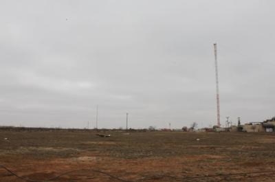
The TV tower, constructed on June 26, 1963 was designated as a "TOWER – Free standing or guyed structure used for communication." The tower was located at latitude 33°32'32.0"N, longitude 101°50'16.0"W and stood 814 ft tall. An FAA study, SW-OE-4136, was issued on January 17, 1963.
Video 1 summary
A review of surveillance video from a building located 1.5 miles north-northeast of the accident site revealed the airplane's lights moving from right to left. At 1930:29, two of the airplane's lights were observed and the airplane appeared to be in a left descending turn. At 1930:32 the airplane passed behind the tower, after which time the airplane's lights were not seen again. At 1930:34 multiple large flashes of light were observed to the left of the tower. At 1930:52 a final large flash of light is observed to the left of the tower.
Video 2 Summary
A review of surveillance video from a building located 0.3 miles north-northwest of the accident site revealed that the airplane entered the camera's field of view on the upper right side and proceeded to the left. Two of the airplane's lights were observed and the airplane appeared to be in a left descending turn. The airplane passed behind the tower. Multiple large flashes of lights were observed to the left of the tower.
Radar data indicated that the accident pilot followed all course and altitude instructions that were provided by ATC without noted deviation. According to audio recordings, the last instruction provided by ATC to the pilot was the approach clearance cancellation and instructions to turn left to a heading of 270 and climb to 7,000 ft. Immediately after the pilot's correct read back acknowledging the controller's instructions, radar data indicated that the accident airplane began a left climbing from of 5,600 ft altitude. It reached an altitude of 5,800 ft, entered a continued left turn through the assigned heading of 270 and then descended rapidly. Radar data revealed only two recorded returns over a 10 second time span after the airplane had reached 5,800 ft. The last recorded radar return indicated an altitude of 5,100 ft at 1930:21. The radar track and accident location were consistent with a rapid continued descending left turn to impact.
On April 21, 2015, an engine examination was performed at Pratt & Whitney Engine Services, Bridgeport West Virginia, under the auspices of an FAA inspector. The examination revealed that the engine exhibited extensive impact damage. The accessory gearbox was completely separated from the engine. Compressive damage was found on the exhaust case and gas generator case. The engine's compressor showed no evidence of pre-impact damage. Rotational signatures were found on the first stage compressor blades. The compressor turbine and power turbine disks and blades exhibited no evidence of pre-impact damage. Light rotational signatures were found in the compressor and power turbines and debris was found in the gas path. There was no evidence of pre-impact anomalies on the reduction and accessory gearboxes. The examination of the engine revealed no preimpact anomalies which would have precluded the engine from producing rated power prior to the accident.
(Image from NTSB report)
 ANN's Daily Aero-Term (04.24.24): Runway Lead-in Light System

