UAV Adapted For Maritime Surveillance Missions
Maritime surveillance requirements are demanding specific capabilities and performance such as mission endurance, flight profiles, mission equipment and human factors. Until recently, such missions were performed exclusively by aircraft – some dedicated for the maritime surveillance mission, with others using off-the-shelf transport planes modified for the mission. These missions typically demand coverage of very wide areas, monitoring extensive maritime traffic, as well as deployment in unexpected conditions, in response to emergencies or on search and rescue missions. Therefore, the need for efficient development of a maritime situational picture is critical, enabling the deployment of the few available aerial assets to cover only those areas or targets of significance.
The introduction of unmanned aircraft platforms is changing this paradigm, removing the limitations that have restricted manned missions, while introducing new capabilities that significantly enhance operational flexibility and efficiency of maritime control. This capability is specifically important in recent years, as countries are required to cover growing maritime areas claimed by the Economical Exclusion Zones (EEZ) that span up to 200 nautical miles from their coastline or farthest island. In the case of India, for example, such area covers a huge expanse of the Indian Ocean, bordering Indonesia in the east to Somalia in the west. A country cannot cover such vast space from its coastal radar stations, nor can it commit manned patrol flights to cover the entire area.
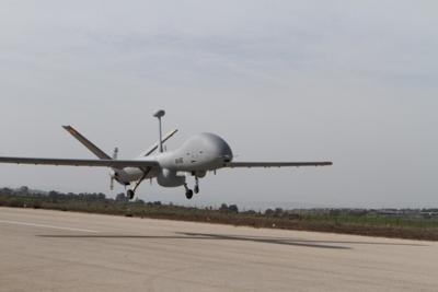
At Aero-India 2013 Elbit Systems is introducing its newest and largest unmanned aircraft system (UAS) - Hermes 900 in a new configuration adapted for maritime mission. This UAS can carry payloads of up to 770 pounds. In the maritime configuration the payload suite includes maritime surveillance radar, AIS, an electro-optical multi-sensor payload and electronic surveillance systems. It has the endurance to cover vast ocean areas, redundant line-of-sight and satellite communications links and radio relay, enabling the operator to ‘talk through’ to vessels at sea. The aerodynamic efficiency of the Hermes 900 enables frequent changes in flight profiles, enabling visual identification of vessels at sea in addition to the ISAR capability provided by the radar. Satellite communication enables it to fly to mission areas at extended ranges as far as 1000 nautical miles from shore.
A unique capability supported by Elbit Systems command and control systems is the ability to control two UAS simultaneously from a single ground control station, using the two redundant data-links. This has a significant effect on the assets, manpower and operating cost, as well as in improving the efficient utilization of UAS that can now cover more area or run a denser surveillance over a given area. The maritime command and control system employed at the ground control is optimized for the maritime mission, supporting specific mission planning applications such as maritime search, Search and Rescue, etc. The entire command and control is located in a single shelter, which can be operated on shore in a mobile shelter base or indoor configurations at sea or co-located in several locations.
Recognizing the extraordinary challenge of monitoring the Indian EEZ and vast shoreline, Elbit Systems has teamed with Windward Ltd. – in order to tackle this challenge from a different point of view and offer a unique solution to the Indian Authorities.
MarInt, Windward's proprietary satellite-based maritime analytics system is capable of covering any area of interest, delivering insightful maritime domain awareness with diverse applications such as EEZ monitoring, illegal fishery monitoring, regional traffic analysis and port traffic management.
By leveraging multiple earth observation satellites and other readily available data sources, MarInt overcomes data overload and conducts multi-source data integration, applying contextual and geo-specific behavior and discrepancy analysis to generate actionable insights.
(Image provided by Elbit Systems)
 ANN's Daily Aero-Term (05.01.24): Say Altitude

