Thu, Apr 10, 2008
 NOTAM Number: FDC 8/2168
Issue Date: April 09, 2008 at 2306 UTC
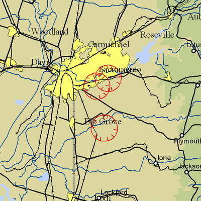
Location: Wilton, California
Beginning Date and Time: April 11, 2008 at 2050 UTC
Ending Date and Time: April 12, 2008 at 0220 UTC
Reason for NOTAM: Temporary flight restrictions for VIP (Very
Important Person) Movement
Type: VIP
Replaced NOTAM(s): 8/2008: Due to Updated times
Affected Area(s)
Area A
Airspace Definition:
Center: On the MC CLELLAN VOR/DME (MCC) 127 degree radial at
7.5 nautical miles. (Latitude: 38º33'55"N, Longitude:
121º18'39"W)
Radius: 3 nautical miles
Altitude: From the surface up to but not including 3000 feet
AGL
Effective Date(s):
From April 11, 2008 at 2050 UTC (April 11, 2008 at 1350
PDT)
To April 11, 2008 at 2140 UTC (April 11, 2008 at 1440
PDT)
Area B
Airspace Definition:
Center: On the MC CLELLAN VOR/DME (MCC) 103 degree radial at
7.3 nautical miles. (Latitude: 38º36'21"N, Longitude:
121º16'10"W)
Radius: 3 nautical miles
Altitude: From the surface up to but not including 3000 feet
AGL
Effective Date(s):
From April 11, 2008 at 2110 UTC (April 11, 2008 at 1410
PDT)
To April 11, 2008 at 2350 UTC (April 11, 2008 at 1650
PDT)
Area C
Airspace Definition:
Center: On the MC CLELLAN VOR/DME (MCC) 132 degree radial at
17.1 nautical miles. (Latitude: 38º25'17"N, Longitude:
121º13'06"W)
Radius: 3 nautical miles
Altitude: From the surface up to but not including 3000 feet
AGL
Effective Date(s):
From April 11, 2008 at 2335 UTC (April 11, 2008 at 1635
PDT)
To April 12, 2008 at 0145 UTC (April 11, 2008 at 1845
PDT)
Area D
Airspace Definition:
Center: On the MC CLELLAN VOR/DME (MCC) 127 degree radial at
7.5 nautical miles. (Latitude: 38º33'55"N, Longitude:
121º18'39"W)
Radius: 3 nautical miles
Altitude: From the surface up to but not including 3000 feet
AGL
Effective Date(s):
From April 12, 2008 at 0130 UTC (April 11, 2008 at 1830
PDT)
To April 12, 2008 at 0220 UTC (April 11, 2008 at 1920
PDT)
Operating Restrictions and Requirements
No pilots may operate an aircraft in the areas covered by this
NOTAM (except as described).
Unless otherwise authorized by ATC.
Other Information:
ARTCC: ZOA - Oakland Center
Authority: Title 14 CFR section 91.141
FMI: www.tfr.faa.gov,
Depicted TFR data may not be a complete listing. Pilots should not
use the information on this website for flight planning purposes.
For the latest information, call your local Flight Service Station
at 1-800-WX-BRIEF.
More News
Say Altitude Used by ATC to ascertain an aircraft's specific altitude/flight level. When the aircraft is climbing or descending, the pilot should state the indicated altitude round>[...]
Aero Linx: European Air Law Association (EALA) EALA was established in 1988 with the aim to promote the study of European air law and to provide an open forum for those with an int>[...]
From 2023 (YouTube Version): The Life, Death, Life, Death, and Life of a Glorious Warbird In 1981, business-owner Jim Tobul and his father purchased a Chance-Vought F4U Corsair. Mo>[...]
Also: USCG Retires MH-65 Dolphins, Irish Aviation Authority, NATCA Warns FAA, Diamond DA42 AD This summer, history enthusiasts will have a unique opportunity to experience World Wa>[...]
Also: WACO Kitchen Bails, French SportPlane Mfr to FL, Dynon-Advance Flight Systems, Innovation Preview Bobby Bailey, a bit of a fixture in sport aviation circles for his work with>[...]
 ANN's Daily Aero-Term (05.01.24): Say Altitude

