Adds U.K. Charts, Support For X-Plane 10, Other Features
Garmin has released an updated version of the Garmin Pilot app, which integrates with the new GTX 345 all-in-one ADS-B transponder. Additionally, the latest iOS version incorporates a new flight profile view, airspace altitude labels, trip planning enhancements, United Kingdom VFR charts for international pilots, support for X-Plane 10 and more.
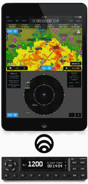
Regardless of existing avionics configuration, the new GTX 345 ADS-B In/Out transponder pairs with Garmin --- Pilot for iOS to wirelessly display the following benefits:
- Subscription-free Flight Information Service-Broadcast (FIS-B) weather
- Complete picture of ADS-B equipped traffic, leveraging exclusive TargetTrend and TerminalTraffic
- GPS position information
- Back-up attitude information powering the rich, SVX synthetic vision and Garmin panel
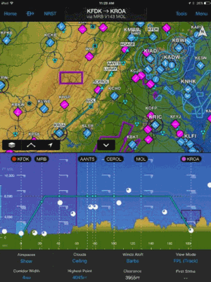
A vertical cross section of airspace, terrain, obstacles and weather display to give pilots a more detailed look at their intended route of flight. When selecting a desired altitude, terrain is color-coded so it’s easy to identify potential conflicts. Airspace and weather can also be selected within profile view to display additional information. Pilots can optionally pinch-and-zoom within the flight profile view to receive a more detailed view of their flight plan at-a-glance. In addition to departure and destination airport pairs, waypoints within a flight plan are denoted as white dashed lines within the flight profile view for easy reference. Flight profile view is only available on iPad mobile devices.
Similar to airspace labels found on a sectional chart, Garmin Pilot’s rich, interactive maps now display maximum and minimum airspace altitude labels. Altitude labels offer pilots added situational awareness in congested airspace and allow for easier identification in unfamiliar airspace segments. Selecting ‘Airspace’ in the Advanced Map Setup page allows pilots to configure airspace labels to best suit their needs.
Garmin has partnered with NATS to bring new and enhanced optional VFR chart coverage within the United Kingdom. Chart coverage includes:
- Scotland
- Northern England and Northern Ireland
- Southern England and Wales
Additionally, VFR chart coverage throughout France is expected to be available in April within Garmin Pilot for iOS.
Pilots can more easily select the best suitable altitude for their intended route of flight using the Altitude Selector Guide. The Altitude Selector Guide can be accessed within the Trip Planning form, which displays fuel burn, estimated time enroute, as well as headwind or tailwind components. Pilots can then select IFR/VFR and an East/West heading to derive the correct altitude for their flight. Further aiding in fuel and trip planning, a Minimum Flight Requirement warning will populate when the TAF for the departure or destination airports is at or below IFR minimums. This warning populates as a yellow triangle in the following areas:
- Trip Planning icon on the main menu
- Departure/destination airport on the Trip Planning form
- Within the Upcoming Trip page
For IFR flights, the Alternate Airport Selection Guide displays airport information along with ceiling and visibility. Pilots can simply select an airport to easily file it as an alternate airport.
Garmin Pilot now supports X-Plane 10 or higher. Customers may launch X-Plane and connect Garmin Pilot to the simulator via Wi-Fi. Once the connection is made, Garmin Pilot conveniently sends AHRS and GPS information to display flight plan information within the application and the simulator.
The airport widget tab has been enhanced to provide easy access to pertinent airport information, including elevation, frequency, runway and non-standard traffic pattern.
The latest version of Garmin Pilot for iOS is available immediately in the U.S. as a free update for existing Garmin Pilot subscribers. The new United Kingdom VFR charts are available starting at $34.99. For new customers, Garmin Pilot is available in the Apple App store as a free trial for the first 30 days.
(Images provided with Garmin news release)
 ANN's Daily Aero-Term (04.24.24): Runway Lead-in Light System

