Modified Predator B Flies First Operational Sorties
The West Coast of the United States has suffered extreme heat
and drought this summer, leading to greater danger of wildfires.
NASA and the US Forest Service are testing aerospace
agency-developed technologies to improve wildfire imaging and
mapping capabilities.
Aero-News has learned that from mid-August through September,
NASA's Dryden Flight Research Center is conducting flights of a
remotely piloted unmanned aircraft system to demonstrate the
capabilities of its sophisticated new imaging and real-time
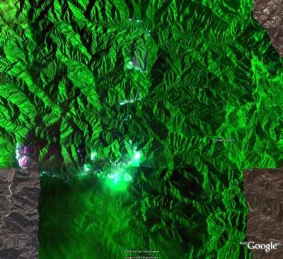
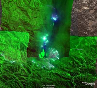
communications equipment. The first flight of the series August 16
captured images of California wildfires, including the Zaca Fire in
Santa Barbara County. The aircraft carried instruments that
collected data while flying more than 1,200 miles over a 10-hour
period.
"The images from the flight demonstrated that this technology
has a future in helping us fight wildland fires," stated Zaca
Incident Commander Mike Dietrich. "We could see little on the
ground since the fire was generating a lot of smoke and burning in
a very remote and inaccessible area. This technology captured
images through the smoke and provided real time information on what
the fire was doing," said Dietrich.
"These tests are a ground-breaking effort to expand the use of
unmanned aircraft systems in providing real-time images in an
actual fire event," said Vincent Ambrosia, principal investigator
of the Western States Fire Mission at NASA's Ames Research Center,
Moffett Field, CA. "This is a prime example of NASA science and
technology being used to solve real-world problems."
NASA's Ikhana, a Predator B remotely piloted aircraft adapted
for civil missions, is flying its first operational effort during a
series of four or five missions over the western states. Its sensor
payload is collecting detailed thermal-infrared imagery of
wildfires and is demonstrating the ability of unmanned aircraft
systems to collect data continuously for 12 to 24 hours. The second
flight in the series, a mission that will take Ikhana over Idaho
and last an estimated 20 hours, is scheduled for Thursday, August
23.

A satellite data link allows real-time transfer of fire imagery
to virtually anywhere on Earth. Information from the sensor is
transmitted to Ames where it is simultaneously available to the
National Interagency Fire Center in Boise, ID as a Google Earth
overlay and through NASA/Open Geospatial Consortium Web
services.
"The success of these tests will help to refine the future
direction of fire mapping for the wildfire management agencies,"
said Everett Hinkley, liaison and special projects group leader for
the USForest Service, Salt Lake City.
The Autonomous Modular Scanner sensor, designed and built at
Ames, is currently configured to observe fires and other
high-temperature sources. The scanner can detect temperature
differences from less than one-half degree to approximately 1,000
degrees Fahrenheit. These temperature discrimination capabilities
are important to improving fire mapping.
Scientists are also testing the Collaborative Decision
Environment software, a new technology application originally
developed by NASA for the Mars Exploration Rovers. This software is
an interactive tool that allows sharing of vast amounts of
information with members of the mission team for effective planning
and acquisition of imagery over critical fire events.
Dryden completed a six-month process to obtain a Certificate of
Authorization from the FAA allowing an unmanned aircraft to fly
wildfire-sensing missions in the national air space of the western
states.
"In the not-too-distant future, we'll look back at unmanned
aircraft demonstrations like the Western States Fire Mission and
realize that these flights paved the way for civilian uses of
unmanned aircraft that benefit all of us," said Brent Cobleigh,
Ikhana project manager at NASA Dryden.
The aircraft's name, Ikhana, is derived from a Native American
Choctaw word that means intelligent, conscious or aware. NASA
acquired the aircraft in November 2006 and intends to use it for
Earth science and atmospheric science data collection missions.
Pilots from NASA and Ikhana manufacturer General Atomics
Aeronautical Systems, Inc. operate the aircraft from a ground
control station at Dryden, located at Edwards Air Force Base. NASA
sponsorship is provided by the agency's Science Mission
Directorate, Washington, DC.
 Airborne 05.10.24: Icon Auction, Drunk MedEvac Pilot, Bell ALFA

