2006 Bahamas & Caribbean Pilot's Guide Released | Aero-News Network
Aero-News Network
RSS icon RSS feed
podcast icon MP3 podcast
Subscribe Aero-News e-mail Newsletter Subscribe

Airborne Unlimited -- Most Recent Daily Episodes

Episode Date

Airborne-Monday

Airborne-Tuesday

Airborne-Wednesday Airborne-Thursday

Airborne-Friday

Airborne On YouTube

Airborne-Unlimited-04.22.24

Airborne-Unlimited-04.16.24

Airborne-FlightTraining-04.17.24 Airborne-AffordableFlyers-04.18.24

Airborne-Unlimited-04.19.24

Join Us At 0900ET, Friday, 4/10, for the LIVE Morning Brief.
Watch It LIVE at
www.airborne-live.net

Mon, Feb 13, 2006

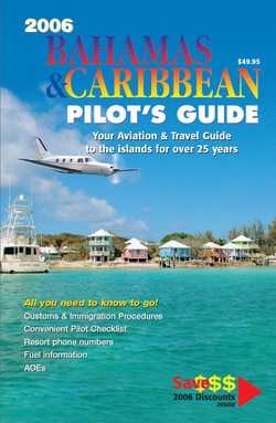
2006 Bahamas & Caribbean Pilot's Guide Released

Plan your Sunny, Island-Hopping Vacation -- By AIR!

Hurricanes hit Florida hard this season, but not the Islands of the Bahamas. There are hundreds of beautiful islands to visit and resorts from small and cozy to large and luxurious — you may have trouble deciding where to go. With almost 60 airports accessible by small plane, you should plan to visit several islands on your dream trip.

The 28th edition of the Bahamas & Caribbean Pilot's Guide provides the information you need to plan that perfect trip. Starting with general information about the islands and specific pilot information with required equipment, survival gear, procedures for entering the Bahamas, forms, Customs & Immigration, and much, much more in clear detail.

The Pilot's Guide is organized by colored tabs for the countries covered: Bahamas; Turks & Caicos; Hispaniola (Dominican Republic and Haiti) and Cuba; Cayman Islands, Jamaica and the Central Caribbean; Puerto Rico and the Virgin Islands; the Eastern Caribbean, and the U.S., which includes South Florida airports with Customs for re-entry to the U.S. Each section has general information about the Country, then island specific details to help you decide where you want to go. There are hundreds of color photos, resort and services phone numbers — it's a great travel book.

There is an aerial color photograph of each airport -- which is a terrific navigation aid.

You'll find all the airport data you need: GPS coordinates, runway numbers and lengths, elevation (mostly 10 feet in the Bahamas), radio frequencies, fuel availability, fees, transportation, Customs & Immigration information, and more. Everything you need is presented in an organized, easy to follow presentation. 

There is also a valuable 16-page Survival section, a fold out map of the Bahamas with a VFR planning chart on the back with distances, and even approach plates for the major airports such as Nassau, Grand Bahama, Providenciales, Isla Grande, St. Thomas, St. Croix, St. Lucia, Kingston, and more.

Updated extensively each year, the book is available for $49.95 from Pilot Publishing, Inc.

FMI: www.flytheislands.com

Advertisement

More News

ANN's Daily Aero-Term (04.25.24): Airport Rotating Beacon

Airport Rotating Beacon A visual NAVAID operated at many airports. At civil airports, alternating white and green flashes indicate the location of the airport. At military airports>[...]

ANN's Daily Aero-Linx (04.25.24)

Aero Linx: Fly for the Culture Fly For the Culture, Inc. is a 501(c)(3) non-profit organization that serves young people interested in pursuing professions in the aviation industry>[...]

Klyde Morris (04.22.24)

Klyde Is Having Some Issues Comprehending The Fed's Priorities FMI: www.klydemorris.com>[...]

Airborne 04.24.24: INTEGRAL E, Elixir USA, M700 RVSM

Also: Viasat-uAvionix, UL94 Fuel Investigation, AF Materiel Command, NTSB Safety Alert Norges Luftsportforbund chose Aura Aero's little 2-seater in electric trim for their next gli>[...]

Airborne 04.22.24: Rotor X Worsens, Airport Fees 4 FNB?, USMC Drone Pilot

Also: EP Systems' Battery, Boeing SAF, Repeat TBM 960 Order, Japan Coast Guard H225 Buy Despite nearly 100 complaints totaling millions of dollars of potential fraud, combined with>[...]

blog comments powered by Disqus


Advertisement

Advertisement

Podcasts

Advertisement

© 2007 - 2024 Web Development & Design by Pauli Systems, LC