Parrot And Survae Announce Partnership | Aero-News Network
Aero-News Network
RSS icon RSS feed
podcast icon MP3 podcast
Subscribe Aero-News e-mail Newsletter Subscribe

Airborne Unlimited -- Most Recent Daily Episodes

Episode Date

Airborne-Monday

Airborne-Tuesday

Airborne-Wednesday Airborne-Thursday

Airborne-Friday

Airborne On YouTube

Airborne-Unlimited-05.13.24

Airborne-NextGen-05.07.24

Airborne-Unlimited-05.08.24 Airborne-FlightTraining-05.09.24

Airborne-Unlimited-05.10.24

Mon, Mar 16, 2020

Parrot And Survae Announce Partnership

Will Pair Enterprise Drone Imagery With Interactive Mapping

European drone group Parrot and Survae, a software platform for managing aerial and ground-based imagery, have launched a partnership through Parrot’s SDK program to combine Parrot’s ANAFI and ANAFI Thermal hardware and Survae’s software for professional drone use.

Parrot’s ANAFI and ANAFI Thermal drones offer an ultra-compact tool for professionals, helping them gain new vantage points to make informed decisions using the drone’s aerial insights. In addition to its built-in 4K HDR camera, ANAFI Thermal also integrates a FLIR thermal sensor— allowing working professionals to easily capture thermal and visual readings for faster response times, along with higher precision and efficiency.

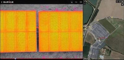
Survae is a next-generation software platform helping enterprise, government and NGOs to visualize and understand places and events by automating video and image processing from a wide range of ground-based and aerial cameras. The company’s cloud-based platform incorporates video, images and sensor data into interactive maps and timelines, providing geospatial and temporal context to organize data so it can be easily searched, visualized, and explored.

Through Survae’s platform, all data is automatically connected to a map and timeline and every frame of the video and imagery is geolocated, date and time stamped. The company’s visual search engine enables users to quickly find relevant data and watch video or images from any point on the map. All video and imagery can be easily shared with Survae’s interactive video/map player, as well.

As part of the new partnership, Parrot ANAFI and ANAFI Thermal drone users can submit visible and thermal videos directly to the Survae platform for easy-access and enhanced footage organization.

“This collaboration is the latest in Parrot’s SDK Partner program,” said Jerome Bouvard, Director of Strategic Partnerships at Parrot. “We are supporting the development of an ecosystem of solutions to meet the unique needs of Parrot’s professional drone users. Survae offers novel capabilities for visualizing and providing context for ANAFI video in both space and time.”

Through its SDK Partner program, Parrot is working with partners to create new professional applications, software and hardware that seamlessly integrate with Parrot ANAFI and ANAFI Thermal drones.

“We have been very impressed by the ANAFI Thermal as a cost effective and intuitive tool for capturing multiple types of imagery,” said Michael Mantell, COO for Survae. “We are excited to offer ANAFI customers powerful spatial and temporal context for their videos in enterprise applications, from long linear inspections and construction site surveys, to emergency response and public safety.”

(Image provided with Parrot news release)

FMI: www.parrot.com

Advertisement

More News

Airborne 05.10.24: Icon Auction, Drunk MedEvac Pilot, Bell ALFA

Also: SkyReach Parts Support, Piper Service Ctr, Airliner Near-Miss, Airshow London The Judge overseeing Icon's convoluted Chapter 11 process has approved $9 million in Chapter 11 >[...]

ANN's Daily Aero-Term (05.13.24): ILS PRM Approach

ILS PRM Approach An instrument landing system (ILS) approach conducted to parallel runways whose extended centerlines are separated by less than 4,300 feet and at least 3,000 feet >[...]

ANN's Daily Aero-Linx (05.13.24)

Aero Linx: FlyPups FlyPups transports dogs from desperate situations to fosters, no-kill shelters, and fur-ever homes. We deliver trained dogs to veterans for service and companion>[...]

Airborne-NextGen 05.07.24: AI-Piloted F-16, AgEagle, 1st 2 WorldView Sats

Also: Skydio Chief, Uncle Sam Sues, Dash 7 magniX, OR UAS Accelerator US Secretary of the Air Force Frank Kendall was given a turn around the patch in the 'X-62A Variable In-flight>[...]

Airborne 05.08.24: Denali Update, Dad-Daughter Gyro, Lake SAIB

Also: NBAA on FAA Reauth, DJI AG Drones, HI Insurance Bill Defeated, SPSA Airtankers The Beechcraft Denali continues moving forward towards certification, having received its FAA T>[...]

blog comments powered by Disqus


Advertisement

Advertisement

Podcasts

Advertisement

© 2007 - 2024 Web Development & Design by Pauli Systems, LC