Modernized Avionics Enhances Situational Awareness, Exceeds Industry Requirements
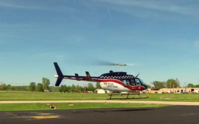
Garmin has announced the selection of a completely integrated Garmin avionics suite by Air Evac Lifeteam for its fleet of Bell 206 and Bell 407 helicopters.
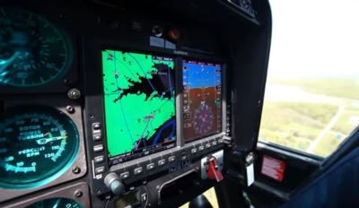
This Night Vision Goggle (NVG) compatible upgrade consists of the G500H glass flight display, GTN 650 touchscreen GPS/NAV/COMM and GTR 225 COMM radio, as well as the GDL 88 ADS-B datalink and GRA 55 radar altimeter. Optimized for rotorcraft, this avionics suite offers robust features that reduce pilot workload and assure fleet commonality.
Additionally, these avionics fulfill Part 135 radar altimeter and Helicopter Air Ambulance (HAA) equipage requirements set forth by the FAA, as well as Helicopter Terrain Awareness and Warning System (HTAWS) and Automatic Dependent Surveillance-Broadcast (ADS-B) initiatives. The Garmin Pilot app completes this comprehensive suite by offering unique helicopter-tailored features so operators are equipped with the latest capabilities.
“The selection of a fully equipped Garmin avionics suite is a declaration of the performance and dependability provided by our equipment and further demonstrates Air Evac’s commitment to providing its crews and patients with the most advanced technology the industry has to offer,” said Carl Wolf, Garmin’s vice president of aviation sales and marketing. “We are excited the relationship with Air Evac has expanded with its growing needs to now provide a comprehensive solution that goes beyond a state-of-the-art avionics suite. Our valued, long-term relationship has evolved to benefit pilots, patients and crew alike and we look forward to supporting Air Evac with the most integrated and advanced avionics suite on the market that enhances situational awareness for their operations.”
Tony Bonham, senior director of flight operations for Air Evac Lifeteam, said the company has a longstanding relationship with Garmin. “Our pilots are excited that Air Evac made a commitment to equip its fleet with the Garmin G500H and GTN 650,” he said. “They have used Garmin’s equipment for several years and are confident the new G500H and GTN 650 will bring a new element of situational awareness to the aircraft.”
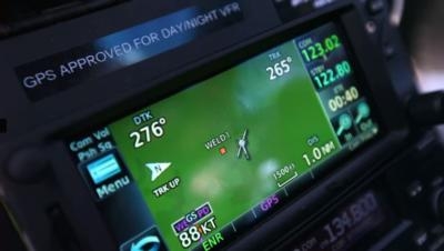
The G500H is a dual-screen electronic flight display system designed specifically for the VFR helicopter market. The primary flight display (PFD) and multi-function display (MFD) within the G500H displays position, altitude, speed and more, directly in the field of view of the pilot. The GTN 650 touchscreen GPS/NAV/COM is seamlessly integrated with the G500H to provide operators with state-of-the-art navigation capabilities. Crew workload is reduced with the GTR 225 COM radio, which incorporates frequency lookup and reverse lookup functions via an internal database on a large, sunlight-readable LCD display.
State-of-the-art HTAWS technology continuously works to monitor surrounding terrain and obstacles.
Operators are provided with visual and aural alerts of potential terrain and obstacle conflicts, which are available within the GTN touchscreen navigator and on the PFD of the G500H. Garmin HTAWS incorporates a five-color terrain scale (red, orange, yellow, green and black) and provides pilot-selectable voice callouts when descending from 500 to 100 feet above ground level (AGL). Furthermore, Garmin’s HTAWS offers Reduced Protection (RP) mode that allows low-level operations with minimal alerting, while continuing to provide terrain and obstacle protection. In addition to HTAWS, optional WireAware wirestrike avoidance technology overlays comprehensive power line location and altitude information on the moving map so they’re easier to identify relative to the flight path of the helicopter.
Helicopter Air Ambulance requirements are easily met with Garmin’s high-performance and cost-effective GRA 55 radar altimeter, which conveniently displays altitudes on the PFD of the G500H. Leveraging patented digital signal processing, this technology incorporates built-in self-test monitors that continuously cross-check system and data integrity, assuring the pilot of an accurate height above ground measurement. In addition to one hundred foot callouts, the GRA 55 offers an additional 50-foot callout when paired with HTAWS.
The dual-link GDL 88 ADS-B datalink provides helicopter operators with a solution to meet ADS-B airspace requirements. For added awareness, traffic information received by the GDL 88 is conveniently displayed on the G500H and GTN 650, which also features audible traffic callouts. Additionally, the GDL 88 receives FAA subscription-free Flight Information Service-Broadcast (FIS-B) weather, displaying graphical NEXRAD radar information, NOTAMs, METARs, TAFs, TFRs and more on the G500H and GTN 650.
The Garmin Pilot app leverages unique helicopter-tailored features, which help Helicopter Air Ambulance operators meet rules recently established by the FAA. When entering a departure and destination pair, Garmin Pilot easily identifies the highest obstacle along the route of flight in mean sea level (MSL) and above ground level (AGL). These obstacles are easily identified on the flight plan page, as well as the moving map page. Additionally, Garmin Pilot provides these operators with convenient access to IFR and VFR Helicopter Route Charts throughout eight major metropolitan areas within the United States.
The Garmin avionics suite selected by Air Evac is NVG compatible. These avionics are supported by Garmin’s aviation support team, which provides 24/7 worldwide technical and warranty support.
(Image from video provided with Garmin news release)
 ANN's Daily Aero-Term (04.25.24): Airport Rotating Beacon

