USGS To Conduct Aerial Fault Mapping In Oklahoma | Aero-News Network
Aero-News Network
RSS icon RSS feed
podcast icon MP3 podcast
Subscribe Aero-News e-mail Newsletter Subscribe

Airborne Unlimited -- Most Recent Daily Episodes

Episode Date

Airborne-Monday

Airborne-Tuesday

Airborne-Wednesday Airborne-Thursday

Airborne-Friday

Airborne On YouTube

Airborne-Unlimited-05.13.24

Airborne-NextGen-05.07.24

Airborne-Unlimited-05.08.24 Airborne-FlightTraining-05.09.24

Airborne-Unlimited-05.10.24

Fri, Aug 18, 2017

USGS To Conduct Aerial Fault Mapping In Oklahoma

Surveys Will Take Six To 10 Weeks To Complete

Scientists with the U.S. Geological Survey and Oklahoma Geological Survey are teaming up to better understand the location of deep faults and subsurface geology via airborne technology.

USGS and OGS are contracting Goldak Airborne Surveys to conduct surveys that will fly over 18 counties in the southwestern and north-central part of the state. The goal is to capture 3-D images of geology beneath the Earth’s surface for earthquake hazard and mineral resources.

Weather permitting, the surveys will take approximately 6-10 weeks to complete. Operations will be based out of Altus, Oklahoma.

“Oklahoma has been experiencing increased seismicity since about 2009. Many of these earthquakes occur on faults that haven’t been mapped,” said USGS scientist and project lead Dr. Anji Shah. “In order to better understand local seismic hazards, the USGS and OGS will use the new data to work towards improved fault maps.”

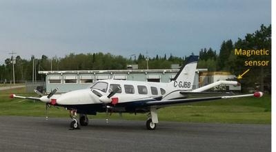
Instruments on the airplane will measure variations in the Earth’s magnetic field created by different rock types up to several miles beneath the surface. The magnetic field maps will help with imaging faults as well as intrusions, which are rocks formed by ancient volcanic eruptions that never reached the surface. The scientific instruments on the airplane are completely passive, with no emissions that pose a risk to humans, animals, or plant life.

Survey areas will include parts of Alfalfa, Beckham, Comanche, Greer, Harmon, Kiowa, Jackson, Lincoln, Logan, Major, Noble, Pawnee, Payne, Pottawatomie, Stephens, Tillman, Woods and Woodward counties.

(Image provided with USGS news release)

FMI: www.usgs.gov

Advertisement

More News

Bolen Gives Congress a Rare Thumbs-Up

Aviation Governance Secured...At Least For a While The National Business Aviation Association similarly applauded the passage of the FAA's recent reauthorization, contentedly recou>[...]

The SportPlane Resource Guide RETURNS!!!!

Emphasis On Growing The Future of Aviation Through Concentration on 'AFFORDABLE FLYERS' It's been a number of years since the Latest Edition of Jim Campbell's HUGE SportPlane Resou>[...]

Buying Sprees Continue: Textron eAviation Takes On Amazilia Aerospace

Amazilia Aerospace GmbH, Develops Digital Flight Control, Flight Guidance And Vehicle Management Systems Textron eAviation has acquired substantially all the assets of Amazilia Aer>[...]

Hawker 4000 Bizjets Gain Nav System, Data Link STC

Honeywell's Primus Brings New Tools and Niceties for Hawker Operators Hawker 4000 business jet operators have a new installation on the table, now that the FAA has granted an STC f>[...]

Echodyne Gets BVLOS Waiver for AiRanger Aircraft

Company Celebrates Niche-but-Important Advancement in Industry Standards Echodyne has announced full integration of its proprietary 'EchoFlight' radar into the e American Aerospace>[...]

blog comments powered by Disqus


Advertisement

Advertisement

Podcasts

Advertisement

© 2007 - 2024 Web Development & Design by Pauli Systems, LC