iFlightPlanner Releases v2.2 | Aero-News Network
Aero-News Network
RSS icon RSS feed
podcast icon MP3 podcast
Subscribe Aero-News e-mail Newsletter Subscribe

Airborne Unlimited -- Most Recent Daily Episodes

Episode Date

Airborne-Monday

Airborne-Tuesday

Airborne-Wednesday Airborne-Thursday

Airborne-Friday

Airborne On YouTube

Airborne-Unlimited-04.22.24

Airborne-Unlimited-04.16.24

Airborne-FlightTraining-04.17.24 Airborne-AffordableFlyers-04.18.24

Airborne-Unlimited-04.19.24

Join Us At 0900ET, Friday, 4/10, for the LIVE Morning Brief.
Watch It LIVE at
www.airborne-live.net

Mon, Jul 28, 2014

iFlightPlanner Releases v2.2

New Features Include Georeferenced Diagrams And Procedures

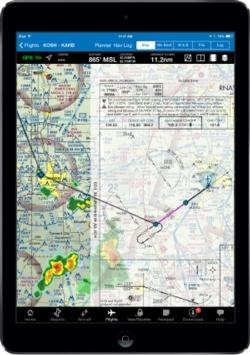
iFlightPlanner has released v2.2 for iPad, the third major update this year to iFlightPlanner for the device presented by Sennheiser.  In addition to numerous performance and usability enhancements, v2.2 now offers the comprehensive set of high-resolution, georeferenced FAA airport diagrams and instrument approach procedures.

The new georeferenced airport diagrams and instrument approach procedures are accessible throughout iFlightPlanner for iPad, including its split-screen view, and can be easily placed over iFlightPlanner’s seamless VFR and IFR charts with a single tap.  Pilots can then use the intuitive mini-menu to quickly search for and switch between other diagrams or approach procedures and adjust the transparency of each.

“We developed our own, proprietary georeferencing process so that when viewed as standalone documents, iFlightPlanner could provide the georeferenced airport diagrams and approach procedures in their original PDF format,” said John Burnside, iFlightPlanner’s Co-Founder & Director of Technology.  “Doing this fully-leverages the pinch and zoom capabilities of the iPad and provides crystal clear readability at any zoom level.”

iFlightPlanner also enhanced its implementation of the Baron Weather API as part of this release, offering pilots the ability to adjust the transparency of RADAR and satellite imagery displayed over its charts and maps.

The new graphical weather functionality is available to all iFlightPlanner Free and Premium members.  Georeferenced airport diagrams and approach procedures are available to iFlightPlanner Premium Plus members, a new membership level introduced to give pilots flying with iFlightPlanner for iPad greater functionality.

(Image provided by iFlightPlanner)

FMI: www.iFlightPlanner.com/Features

Advertisement

More News

ANN's Daily Aero-Term (04.25.24): Airport Rotating Beacon

Airport Rotating Beacon A visual NAVAID operated at many airports. At civil airports, alternating white and green flashes indicate the location of the airport. At military airports>[...]

ANN's Daily Aero-Linx (04.25.24)

Aero Linx: Fly for the Culture Fly For the Culture, Inc. is a 501(c)(3) non-profit organization that serves young people interested in pursuing professions in the aviation industry>[...]

Klyde Morris (04.22.24)

Klyde Is Having Some Issues Comprehending The Fed's Priorities FMI: www.klydemorris.com>[...]

Airborne 04.24.24: INTEGRAL E, Elixir USA, M700 RVSM

Also: Viasat-uAvionix, UL94 Fuel Investigation, AF Materiel Command, NTSB Safety Alert Norges Luftsportforbund chose Aura Aero's little 2-seater in electric trim for their next gli>[...]

Airborne 04.22.24: Rotor X Worsens, Airport Fees 4 FNB?, USMC Drone Pilot

Also: EP Systems' Battery, Boeing SAF, Repeat TBM 960 Order, Japan Coast Guard H225 Buy Despite nearly 100 complaints totaling millions of dollars of potential fraud, combined with>[...]

blog comments powered by Disqus


Advertisement

Advertisement

Podcasts

Advertisement

© 2007 - 2024 Web Development & Design by Pauli Systems, LC