SmarTopo Harvest Develops A 'Safe Zone' For UAVS | Aero-News Network
Aero-News Network
RSS icon RSS feed
podcast icon MP3 podcast
Subscribe Aero-News e-mail Newsletter Subscribe

Airborne Unlimited -- Most Recent Daily Episodes

Episode Date

Airborne-Monday

Airborne-Tuesday

Airborne-Wednesday Airborne-Thursday

Airborne-Friday

Airborne On YouTube

Airborne-Unlimited-05.13.24

Airborne-NextGen-05.07.24

Airborne-Unlimited-05.08.24 Airborne-FlightTraining-05.09.24

Airborne-Unlimited-05.10.24

Tue, Mar 31, 2015

SmarTopo Harvest Develops A 'Safe Zone' For UAVS

New Obstacle Detection Technology For The SmarTopo Obstacle Management System

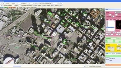
Rapid Imaging Software, Inc. introduced SmarTopo Harvest on Monday. This new technology is integrated into the SmarTopo Obstacle Management System. SmarTopo delivers obstacle survey and detection technology plus powerful data management tools for a complete obstacle management system. SmarTopo is certified by the FAA to a level 1B.

Mike Abernathy, Director of Development notes, “SmarTopo Harvest is the key for small commercial drones to operate safely in urban areas. This technology allows companies to create and maintain an obstacle database for their drone operations."

SmarTopo Harvest is the latest obstacle detection technology from Rapid Imaging Software. The software provides a fast and efficient method to detect undocumented obstacles and add new obstacles to a database.

  • Searches for obstacles – the height for the search is set by the analyst
  • Detected objects or structures may be compared to the FAA obstacle database
  • Estimates height of the objects or structures
  • Creates new obstacle for a proprietary database

The issue of undocumented obstacles is extensive. A recent study conducted using SmarTopo Harvest indicates there are a substantial number of undocumented obstacles in the national airspace. An analyst using SmarTopo Harvest identified 52 undocumented obstacles of 200 feet or more in a study area of six square miles around the Los Angeles International Airport.

(Image provided by Rapid Imaging Software)

FMI: www.rapidimaging.net/obstaclemanagement/

Advertisement

More News

ANN's Daily Aero-Term (05.10.24): Takeoff Roll

Takeoff Roll The process whereby an aircraft is aligned with the runway centerline and the aircraft is moving with the intent to take off. For helicopters, this pertains to the act>[...]

Aero-News: Quote of the Day (05.10.24)

“We’re proud of the hard work that went into receiving this validation, and it will be a welcome relief to our customers in the European Union. We couldn’t be mor>[...]

Aero-News: Quote of the Day (05.11.24)

"Aircraft Spruce is pleased to announce the acquisition of the parts distribution operations of Wag-Aero. Wag-Aero was founded in the 1960’s by Dick and Bobbie Wagner in the >[...]

ANN's Daily Aero-Term (05.11.24): IDENT Feature

IDENT Feature The special feature in the Air Traffic Control Radar Beacon System (ATCRBS) equipment. It is used to immediately distinguish one displayed beacon target from other be>[...]

ANN's Daily Aero-Linx (05.11.24)

Aero Linx: Pararescue Air Force Pararescuemen, also known as PJs, are the only DoD elite combat forces specifically organized, trained, equipped, and postured to conduct full spect>[...]

blog comments powered by Disqus


Advertisement

Advertisement

Podcasts

Advertisement

© 2007 - 2024 Web Development & Design by Pauli Systems, LC