Collected By NASA, JAXA Satellites
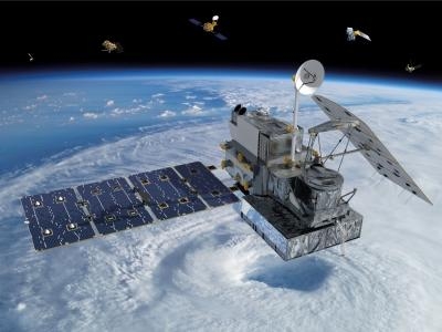
The most accurate and comprehensive collection of rain, snowfall and other types of precipitation data ever assembled now is available to the public. This new resource for climate studies, weather forecasting, and other applications is based on observations by the Global Precipitation Measurement (GPM) Core Observatory, a joint mission of NASA and the Japan Aerospace Exploration Agency (JAXA), with contributions from a constellation of international partner satellites.
The GPM Core Observatory, launched from Japan on Feb. 27, carries two advanced instruments to measure rainfall, snowfall, ice and other precipitation. The advanced and precise data from the GPM Core Observatory are used to unify and standardize precipitation observations from other constellation satellites to produce the GPM mission data. These data are freely available through NASA's Precipitation Processing System at Goddard Space Flight Center in Greenbelt, Maryland.
"We are very pleased to make all these data available to scientists and other users within six months of launch," said Ramesh Kakar, GPM program scientist in the Earth Science Division at NASA Headquarters, Washington.
In addition to NASA and JAXA, the GPM mission includes satellites from the U.S. National Oceanic and Atmospheric Administration, U.S. Department of Defense's Defense Meteorological Satellite Program, European Organisation for the Exploitation of Meteorological Satellites, Indian Space Research Organisation, and France's Centre National d’Études Spatiales.
Instruments on the GPM Core Observatory and partner satellites measure energy naturally emitted by liquid and frozen precipitation. Scientists use computer programs to convert these data into estimates of rain and snowfall. The individual instruments on the partner satellites collect similar data, but the absolute numbers for precipitation observed over the same location may not be exactly the same. The GPM Core Observatory's data are used as a reference standard to smooth out the individual differences, like a principal violinist tuning the individual instruments in an orchestra. The result is data that are consistent with each other and can be meaningfully compared.
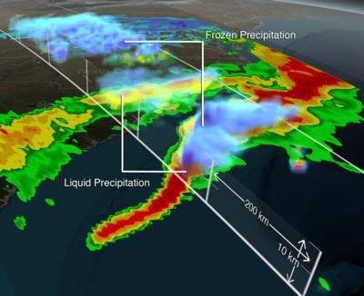
With the higher sensitivity to different types of precipitation made possible by the GPM Core Observatory's Microwave Imager (GMI) and Dual-frequency Precipitation Radar (DPR), scientists can for the first time accurately measure the full range of precipitation from heavy rain to light rain and snow. The instruments are designed not only to detect rain and snow in the clouds, but to measure the size and distribution of the rain particles and snowflakes. This information gives scientists a better estimate of water content and a new perspective on winter storms, especially near the poles where the majority of precipitation is snowfall.
"With this GPM mission data, we can now see snow in a way we could not before," said Gail Skofronick-Jackson, GPM project scientist at Goddard Space Flight Center. "Cloud tops high in the atmosphere have ice in them. If the Earth’s surface is above freezing, it melts into rain as it falls. But in some parts of the world, it's cold enough that the ice and snow falls all the way to the ground."
One of the first storms observed by the GPM Core Observatory on March 17 in the eastern United States showed that full range of precipitation. Heavy rains fell over the North and South Carolina coasts. As the storm moved northward, West Virginia, Virginia, Maryland and Washington were covered with snow. The GMI observed an 547 mile-wide track of precipitation on the surface, while the DPR imaged every 820 feet vertically to get the three-dimensional structure of the rain and snowfall layer by layer inside the clouds.
"What's really clear in these images is the melting layer, the place in the atmosphere where ice turns into rain," said Skofronick-Jackson. "The melting layer is one part of the precipitation process that scientists don’t know well because it is in such a narrow part of the cloud and changes quickly. Understanding the small scale details within the melting layer helps us better understand the precipitation process."
The combined snowfall and rainfall measurements from GPM will fill in the picture of where and how water moves throughout the global water cycle.
"Scientists and modelers can use the new GPM data for weather forecasts, estimating snowpack accumulation for freshwater resources, flood and landslide prediction, or tracking hurricanes," Skofronick-Jackson said. "This revolutionary information also gives us a better grasp of how storms and precipitating systems form and evolve around the planet, providing climate modelers insight into how precipitation might change in a changing climate."
GPM data are freely available to registered users from Goddard's Precipitation Processing System (PPS) website. The data sets are currently available in strips called swaths that correspond to the satellites' overpasses. Daily and monthly, global maps are also available from all the sensors. In the coming months, the PPS will merge this instrument data from all partner satellites and the Core Observatory into a seamless map that shows global rain and snow data at a 6-mile resolution every 30 minutes.
The GPM Core Observatory was the first of five scheduled NASA Earth science missions launching within a year. NASA monitors Earth's vital signs from land, air and space with a fleet of satellites and ambitious airborne and ground-based observation campaigns. NASA also develops new ways to observe and study Earth's interconnected natural systems with long-term data records and computer analysis tools to better see how our planet is changing. The agency freely shares this unique knowledge with the global community and works with institutions in the United States and around the world that contribute to understanding and protecting our home planet.
(Image provided by NASA)
 ANN's Daily Aero-Term (04.24.24): Runway Lead-in Light System

