GPM Core Observatory Made Five Passes Over Arthur Last Week
The Global Precipitation Measurement (GPM) Core Observatory flew over Hurricane Arthur five times between July 1 and July 5, 2014. Arthur was the first tropical cyclone of the 2014 Atlantic hurricane season.
GPM is a joint mission between NASA and the Japan Aerospace Exploration Agency. The Core Observatory was launched Feb. 27 from Japan and began its prime mission on May 29, just in time for the hurricane season.
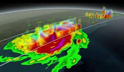
The five GPM passes over Arthur are the first time a precipitation-measuring satellite has been able to follow a hurricane through its full life cycle with high-resolution measurements of rain and ice. In the July 3 image, Arthur was just off the coast of South Carolina. GPM data showed that the hurricane was asymmetrical, with spiral arms, called rain bands, on the eastern side of the storm but not on the western side.
Arthur was born as the first 2014 Atlantic tropical depression on June 30. It strengthened into a tropical storm on July 1 and reached maximum intensity as a Category 2 hurricane on July 4. The storm moved up the U.S. East Coast and made landfall on July 3 at 11:15 p.m. EDT over the Shackleford Banks between Cape Lookout and Beaufort, North Carolina, before swinging northeast over the ocean toward Greenland, where it became an extra-tropical storm on July 5.
“With these new observations we are able to see fine scale structures of precipitation to about 1,000 feet vertically and 3 miles horizontally. This allows us to measure precipitation regionally and to improve weather forecasting models,” said Gail Skofronick-Jackson, GPM project scientist at NASA's Goddard Space Flight Center in Greenbelt Maryland.
The GPM Core Observatory’s observations of storms like Arthur will also help scientists decipher some of the thorniest questions about hurricanes, such as how and why they intensify. Hurricane intensity is one of the most difficult aspects to predict and is an area of active research that GPM's observations will contribute to, said NASA Goddard hurricane researcher Scott Braun.
The spacecraft carries two instruments that show the location and intensity of the rain, which defines a crucial part of the storm structure. The GPM Microwave Imager sees through the tops of clouds to observe how much and where precipitation occurs, and the Dual-frequency Precipitation Radar observes precise details of precipitation in three dimensions.
With the added capability and higher resolution on the new instruments, "hurricane features pop out more. They're sharper, there's more clarity to the structures," said Braun. "Being able to see the structures more clearly may allow for better determination of the structure of the eye wall and rainbands, thereby providing clues about the likelihood of a storm intensifying or weakening.”
For forecasters, GPM's radiometer and radar data are part of the toolbox of satellite data that they use to monitor tropical cyclones and hurricanes. This toolbox includes data from other low Earth orbit and geostationary satellites.
"The whole idea here is to use these tools to understand the initial genesis of the tropical cyclone, then to monitor its location, eye structure and intensity as it evolves, and to use that along with our numerical model forecast to generate a five- to seven-day forecast every six hours," said Jeff Hawkins, head of the Satellite Meteorological Applications Section for the Naval Research Laboratory in Monterey, California. His group is an early adopter of GPM data and monitors near-real time tropical cyclones worldwide. They distribute satellite products generated from multiple satellites' data to operational and research users, including the Navy and Air Force's Joint Typhoon Warning Center in Hawaii and the U.S. National Hurricane Center in Florida.
The addition of GPM data to the current suite of satellite data is timely. Its predecessor precipitation satellite, the Tropical Rainfall Measuring Mission, is in the17th year of its operation. GPM's new high-resolution microwave imager data and the unique radar data ensure that forecasters and modelers won't have a gap in coverage.
All GPM data products will be released to the public by Sept. 2, 2014.
(Image provided by NASA)
 ANN's Daily Aero-Term (04.24.24): Runway Lead-in Light System

