Warmer Waters Shift Towards The Central Pacific, Effect On
Weather Still Not Known
 A relatively new type of El Niño, which has its warmest
waters in the central-equatorial Pacific Ocean, rather than in the
eastern-equatorial Pacific, is becoming more common and
progressively stronger, according to a new study by NASA and NOAA.
The research may improve our understanding of the relationship
between El Niños and climate change, and has potential
significant implications for long-term weather forecasting.
A relatively new type of El Niño, which has its warmest
waters in the central-equatorial Pacific Ocean, rather than in the
eastern-equatorial Pacific, is becoming more common and
progressively stronger, according to a new study by NASA and NOAA.
The research may improve our understanding of the relationship
between El Niños and climate change, and has potential
significant implications for long-term weather forecasting.
Lead author Tong Lee of NASA’s Jet Propulsion Laboratory,
Pasadena, CA, and Michael McPhaden of NOAA’s Pacific Marine
Environmental Laboratory in Seattle measured changes in El
Niño intensity since 1982. They analyzed NOAA satellite
observations of sea surface temperature, checked against and
blended with directly-measured ocean temperature data. The strength
of each El Niño was gauged by how much its sea surface
temperatures deviated from the average. They found the intensity of
El Niños in the central Pacific has nearly doubled over the
study period, with the most intense event occurring in 2009-10.
The scientists say the stronger El Niños help explain a
steady rise in central Pacific sea surface temperatures observed
over the past few decades in previous studies — a trend
attributed by some to the effects of global warming. While Lee and
McPhaden observed a rise in sea surface temperatures during El
Niño years, no significant temperature increases were seen
in years when ocean conditions were neutral, or when El
Niño’s cool water counterpart, La Niña, was
present.
 “Our study concludes the long-term warming trend seen in
the central Pacific is primarily due to more intense El
Niños, rather than a general rise of background
temperatures,” said Lee.
“Our study concludes the long-term warming trend seen in
the central Pacific is primarily due to more intense El
Niños, rather than a general rise of background
temperatures,” said Lee.
“These results suggest climate change may already be
affecting El Niño by shifting the center of action from the
eastern to the central Pacific,” said McPhaden. “El
Niño’s impact on global weather patterns is different
if ocean warming occurs primarily in the central Pacific, instead
of the eastern Pacific.”
“If the trend we observe continues,” McPhaden
continued, “it could throw a monkey wrench into long-range
weather forecasting, which is largely based on our understanding of
El Niños from the latter half of the 20th
century.”
El Niño (Spanish for “the little boy”) is the
oceanic component of a climate pattern called the El
Niño-Southern Oscillation, which appears in the tropical
Pacific Ocean on average every three to five years. The most
dominant year-to-year fluctuating pattern in Earth’s climate
system, El Niños have a powerful impact on the ocean and
atmosphere, as well as important socioeconomic consequences. They
can influence global weather patterns and the occurrence and
frequency of hurricanes, droughts and floods; and can even raise or
lower global temperatures by as much as 0.2 degrees Celsius (0.4
degrees Fahrenheit).
During a “classic” El Niño episode, the
normally strong easterly trade winds in the tropical eastern
Pacific weaken. That weakening suppresses the normal upward
movement of cold subsurface waters and allows warm surface water
from the central Pacific to shift toward the Americas. In these
situations, unusually warm surface water occupies much of the
tropical Pacific, with the maximum ocean warming remaining in the
eastern-equatorial Pacific.
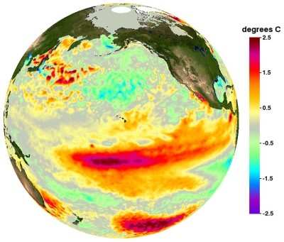
Image produced by Physical Oceanography Distributed Active
Archive Center
Since the early 1990s, however, scientists have noted a new type
of El Niño that has been occurring with greater frequency.
Known variously as “central-Pacific El Niño,”
“warm-pool El Niño,” “dateline El
Niño” or “El Niño Modoki” (Japanese
for “similar but different”), the maximum ocean warming
from such El Niños is found in the central-equatorial,
rather than eastern, Pacific. Such central Pacific El Niño
events were observed in 1991-92, 1994-95, 2002-03, 2004-05 and
2009-10.
Lee said further research is needed to evaluate the impacts of
these increasingly intense El Niños and determine why these
changes are occurring. Results of the study were published recently
in Geophysical Research Letters.
 Samson Sky Hits the Wind Tunnel