Mon, Sep 27, 2010
While ANN was running around/amok at Oshkosh (much like a
certain poultry product sans any evidence of cranial capacity), we
were hard-pressed to keep up with all the goodies that were
presented... but the crowds surrounding the Jepp building convinced
us that it was worth spending a few hours there... and we were NOT
disappointed.
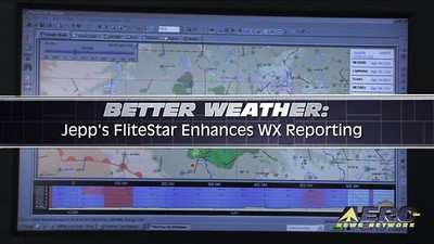
During the annual aerial love-fest at Oshkosh, Jepp took the
wraps off a new version of its new FliteStar flight planning
program that now includes enhanced global weather data services.
Jeppesen FliteStar users will now be able to improve situational
awareness through receiving continually updated weather
information. Weather data is now presented through multiple
customized graphical formats displayed according to FliteStar
coverage area, user preference and flight plan.

The ground-based FliteStar version 9.5 presents users with a
dynamic graphical view of the weather environment in both enroute
and profile views and reduces the need to switch between enroute
and weather displays. Jeppesen weather data now aligns with the
FliteStar coverage area purchased and weather download overlay
displays are presented on enroute charts and are updated
automatically through an Internet connection. The new version of
the FliteStar program provides a new tool to view current weather
at or near the time of departure plus forecast weather along a
route and at a user’s planned destination. The weather
service combines current data from the National Weather Service and
other sources, including NEXRAD mosaic data and includes critical
icing and turbulence information.
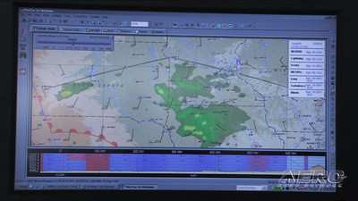
Weather elements included in the new FliteStar version includes
AIRMETs, SIGMETs, radar, lighting, surface analysis, METARs, icing,
turbulence and wind data. A new weather toolbar gives users the
ability to display or close these graphical elements, according to
user preference. A new “chart time slider” feature
allows users to view current weather for the flight plan and a new
“weather legend” graphical element shows all currently
displayed weather elements. An “icing” display bar
allows users to formulate an ice-avoidance strategy and flight plan
before leaving the ground. By the way, ANN is currently evaluating
a copy of the latest version of FliteStar and the weather
capabilities are every bit as slick as promised. The current
version of FligteStar is packed to the gills with features and
we're looking forwards to checking each of them out... More news to
follow. In the meantime, though, check out the Aero-TV interview
with the folks at Jepp about the new weather reporting functions
built into FliteStar.
More News
Airport Marking Aids Markings used on runway and taxiway surfaces to identify a specific runway, a runway threshold, a centerline, a hold line, etc. A runway should be marked in ac>[...]
"It is extremely difficult, if not impossible, for manned aircraft to see a drone while conducting crop-enhancing and other aerial applications at low altitudes and high speeds. We>[...]
Aero Linx: The Skyhawk Association The Skyhawk Association is a non-profit organization founded by former Skyhawk Pilots which is open to anyone with an affinity for the A-4 Skyhaw>[...]
“The T-54A benefits from an active Beechcraft King Air assembly line in Wichita, Kansas, where all required METS avionics and interior modifications are installed on the line>[...]
Aero Linx: Aerostar Owners Association The Association offers the Aerostar Owner a unique opportunity to tap an invaluable source of information concerning the care and feeding of >[...]
 ANN's Daily Aero-Term (04.28.24): Airport Marking Aids

