NOAA Using UAVs In Hurricane Noel | Aero-News Network
Aero-News Network
RSS icon RSS feed
podcast icon MP3 podcast
Subscribe Aero-News e-mail Newsletter Subscribe

Airborne Unlimited -- Most Recent Daily Episodes

Episode Date

Airborne-Monday

Airborne-Tuesday

Airborne-Wednesday Airborne-Thursday

Airborne-Friday

Airborne On YouTube

Airborne-Unlimited-04.29.24

Airborne-Unlimited-04.23.24

Airborne-Unlimited-04.24.24 Airborne-FltTraining-04.25.24

Airborne-Unlimited-04.26.24

Sun, Nov 04, 2007

NOAA Using UAVs In Hurricane Noel

Low Level Flights Hoped To Produce New Data

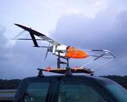
Hurricane Noel is giving researchers their first chance to test out Unmanned Aerial Vehicles as hurricane research aircraft. The remote controlled plane was launched November 2, from Wallops Island, VA, the National Oceanic and Atmospheric Administration told the Associated Press.

The craft will fly into the storm at low level to measure its winds, which have been averaging about 80 mph. testing the aircraft’s strength and ability to monitor the storm while in flight.

The Aerosonde-built UAV is five feet long with a wing span of 10 feet and was expected to penetrate the hurricane eyewall or storm center Friday night, November 2 during its anticipated 20 hour long mission.

"Unmanned flights at very low altitude are important since they give us unique insights and continuous observations in a region of the storm where the ocean's energy is directly transferred to the atmosphere just above. Attempting this type of research flight with our hurricane hunter aircraft would risk the lives of our crew and scientists," said Joe Cione, hurricane researcher at NOAA's Atlantic Oceanographic and Meteorological Laboratory in Miami, and project manager for the Aerosonde field study.

The flights will be monitored by Cione from NOAA’s Miami based National Hurricane Center.

Agency officials said that scientists are hoping for new data from near surface flights that are too risky for manned flights.

FMI: www.noaa.gov, www.aerosonde.com/

Advertisement

More News

Unfortunate... ANN/SportPlane Resource Guide Adds To Cautionary Advisories

The Industry Continues to be Rocked By Some Questionable Operations Recent investigations and a great deal of data has resulted in ANN’s SportPlane Resource Guide’s rep>[...]

ANN FAQ: Turn On Post Notifications

Make Sure You NEVER Miss A New Story From Aero-News Network Do you ever feel like you never see posts from a certain person or page on Facebook or Instagram? Here’s how you c>[...]

ANN's Daily Aero-Term (04.29.24): Visual Approach Slope Indicator (VASI)

Visual Approach Slope Indicator (VASI) An airport lighting facility providing vertical visual approach slope guidance to aircraft during approach to landing by radiating a directio>[...]

ANN's Daily Aero-Term (04.28.24): Airport Marking Aids

Airport Marking Aids Markings used on runway and taxiway surfaces to identify a specific runway, a runway threshold, a centerline, a hold line, etc. A runway should be marked in ac>[...]

ANN's Daily Aero-Linx (04.28.24)

Aero Linx: The Skyhawk Association The Skyhawk Association is a non-profit organization founded by former Skyhawk Pilots which is open to anyone with an affinity for the A-4 Skyhaw>[...]

blog comments powered by Disqus


Advertisement

Advertisement

Podcasts

Advertisement

© 2007 - 2024 Web Development & Design by Pauli Systems, LC