Designed Save Pilots And Operators Time And Enhance Safety
Honeywell Aerospace is offering new software upgrades for Primus Epic, the company’s integrated cockpit system that is flying on the world’s most advanced aircraft. The new capabilities will help pilots better avoid collision and extreme weather, and allow them to make faster decisions for safer and more efficient flights.
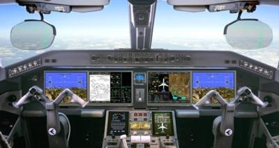
Primus Epic enhancements will further streamline the cockpit for pilots, providing access to the right information at the right time. Upgrades include IntuVue 3-D Weather Radar Hazard 2.0, Honeywell’s latest upgrade of the system that features hail and lightning detection, Traffic Collision Avoidance System (TCAS) coupled autopilot, DynaCharts — integrated arrival and departure terminal charts with the navigational display, and new mobile applications that enhance pilot and maintenance efficiency.
“Primus Epic is designed to remain next generation, so Honeywell is constantly incorporating the latest breakthrough technology into the system to ensure we meet or exceed the standards of our customers,” says Jeff Merdich, vice president, Marketing for Cockpit Systems, Honeywell Aerospace. “With its advanced software-based architecture, Primus Epic delivers unprecedented value to operators by allowing for easy-to-install, cost-effective updates that enhance aircraft safety and efficiency.”
Honeywell DynaCharts is the industry’s first integration of critical arrival and departure standard charts information with the cockpit navigation display. Previously, pilots would have to look at the navigation map and pre-composed charts in tandem during the busiest phases of flight — takeoff and landing. With DynaCharts, pilots can now see all of the relevant information from the charted procedure, at the right time and on a single Interactive Navigation display. It gives them the information in the context of the flight plan, terrain, airspace and weather to increase safety and efficiency.
IntuVue 3-D Weather Radar is the industry’s leading 3-D weather radar. The latest version, Hazard 2.0, includes a predictive hail, lightning and extended turbulence detection that can minimize the impact of severe weather on operators and passengers. Hazard 2.0 is able to predict storms with hail and lightning and detect turbulence out to 60 nm. IntuVue is the first and only automatic radar to accurately depict weather in an aircraft’s flight path and provide turbulence detection up to 60 nautical miles ahead. It gives pilots better information faster, so they can make quick decisions to reroute around bad weather contributing to safer and more efficient flight travel.
Honeywell’s new TCAS Coupled Autopilot will automatically steer the aircraft away from potential collisions with other aircraft. The system works with guidance from the TCAS system itself, helping pilots avoid incidents while performing smooth and safe avoidance maneuvers. Studies have shown that a slow pilot response to Resolution Advisory from TCAS is often followed by an aggressive dive or climb, which raises risk of injury to passengers. This automated function ensures quick and correct avoidance maneuver and allows pilots to monitor aircraft flight path while assessing the danger of the traffic alert.
New tablet-based tools will be available to assist pilots and maintenance personnel in securing and processing information more efficiently. New applications such as a taxi guidance mobile app for depicting clearances on an airport moving map, procedure approach preview tool for displaying planned flight management trajectories and waypoints over terrain in day or night conditions, and electronic logging of pilot and maintenance reports — along with the wireless connectivity available with Primus Epic — allow for rapid deployment of high-value enhancements to aid aircraft operation and support.
(Source: Honeywell news release. Image from file)
 ANN's Daily Aero-Term (05.17.24): Very High Frequency

