FAA’s B4UFLY App Will Help UAS Pilots Operate Safely And Legally | Aero-News Network
Aero-News Network
RSS icon RSS feed
podcast icon MP3 podcast
Subscribe Aero-News e-mail Newsletter Subscribe

Airborne Unlimited -- Most Recent Daily Episodes

Episode Date

Airborne-Monday

Airborne-Tuesday

Airborne-Wednesday Airborne-Thursday

Airborne-Friday

Airborne On YouTube

Airborne-Unlimited-04.29.24

Airborne-Unlimited-04.23.24

Airborne-Unlimited-04.24.24 Airborne-FltTraining-04.25.24

Airborne-Unlimited-04.26.24

Thu, May 07, 2015

FAA’s B4UFLY App Will Help UAS Pilots Operate Safely And Legally

Initially For iOS Devices, Agency Says Android Version Coming Soon

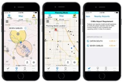
The FAA on Wednesday demonstrated a new smartphone application called “B4UFLY,” designed to help model aircraft and unmanned aircraft (UAS) users know if it is safe and legal to fly in their current or planned location.

“We want to make sure hobbyists and modelers know where it is and isn’t okay to fly,” said FAA Administrator Michael Huerta. “While there are other apps that provide model aircraft enthusiast with various types of data, we believe B4UFLY has the most user-friendly interface and the most up-to-date information.”

FAA says B4UFLY is a simple, easy-to-use app that users can access before they operate their aircraft to determine whether there are any restrictions or requirements in effect at the location where they want to fly. The FAA announced the app at the Association for Unmanned Vehicle Systems International Unmanned Systems 2015 conference in Atlanta, Ga., and plans to release the app to approximately 1,000 beta testers later this summer.

Key features of the B4UFLY app include:

  • A clear “status” indicator that immediately informs operators about their current or planned location.
  • Information on the parameters that drive the status indicator.
  • A “Planner Mode” for future flights in different locations.
  • Informative, interactive maps with filtering options.
  • Contact information for nearby airports.
  • Links to other FAA UAS resources and regulatory information.

The beta test is expected to run for several months, after which the FAA plans to make B4UFLY available for the general public. The initial release is planned for iOS devices only, with an Android version to follow.

B4UFLY complements the Know Before You Fly educational campaign, which provides prospective UAS operators with information and guidance they need to fly safely and responsibly. The FAA is a partner in the effort with the Association for Unmanned Vehicle Systems International (AUVSI), Academy of Model Aeronautics (AMA), and the Small UAV Coalition.

In a statement, the Academy of Model Aeronautics called the app a "valuable tool to help make it easier for recreational unmanned aircraft enthusiasts to operate their aircraft in a safe and responsible manner. Much like our ‘Know Before You Fly’ campaign, this app demonstrates that education is the best way to ensure the safe use of this technology. AMA looks forward to working with the FAA to test and improve this application to make it the most valuable tool possible for all users of unmanned aircraft”
 
In addition, at least 100 AMA members will be assisting the FAA with beta-testing for the new app this summer.
 
In December, AMA, AUVSI and the Small UAV Coalition launched the Know Before You Fly campaign. The FAA also joined as a partner. The campaign is educating consumers and business users about the safe and responsible operation of UAS, including who can currently fly, where they can fly and for what purposes. More information can be found at .

www.faa.gov/uas, http://KnowBeforeYouFly.org

Advertisement

More News

Unfortunate... ANN/SportPlane Resource Guide Adds To Cautionary Advisories

The Industry Continues to be Rocked By Some Questionable Operations Recent investigations and a great deal of data has resulted in ANN’s SportPlane Resource Guide’s rep>[...]

ANN FAQ: Turn On Post Notifications

Make Sure You NEVER Miss A New Story From Aero-News Network Do you ever feel like you never see posts from a certain person or page on Facebook or Instagram? Here’s how you c>[...]

ANN's Daily Aero-Term (04.29.24): Visual Approach Slope Indicator (VASI)

Visual Approach Slope Indicator (VASI) An airport lighting facility providing vertical visual approach slope guidance to aircraft during approach to landing by radiating a directio>[...]

ANN's Daily Aero-Term (04.28.24): Airport Marking Aids

Airport Marking Aids Markings used on runway and taxiway surfaces to identify a specific runway, a runway threshold, a centerline, a hold line, etc. A runway should be marked in ac>[...]

ANN's Daily Aero-Linx (04.28.24)

Aero Linx: The Skyhawk Association The Skyhawk Association is a non-profit organization founded by former Skyhawk Pilots which is open to anyone with an affinity for the A-4 Skyhaw>[...]

blog comments powered by Disqus


Advertisement

Advertisement

Podcasts

Advertisement

© 2007 - 2024 Web Development & Design by Pauli Systems, LC