Says RV-10 'Drifted Off Course' And Impacted Mountainous Terrain
The NTSB says the pilot of an RV-10 which went down near Lake Placid, NY, in February attempted to land VFR at night in IFR conditions. The accident made headlines back in February, as the pilot and his two passengers all not only survived the accident, but several hours in sub-freezing temperatures waiting for rescue.
According to the NTSB's Probable Cause report, the pilot received weather information and filed an IFR flight plan before departure. As the pilot approached his destination, which was surrounded by high terrain, the scattered cloud layer below him became broken and light conditions were dimming as the sun set. After seeing a break in the clouds and being uncomfortable with what he observed, the pilot requested the GPS-A approach then maneuvered to intercept the inbound course at the initial approach fix (IAF).
Before reaching the IAF, he saw a clear visual path to his destination. At the same time, the air traffic controller was awaiting cancellation from a landing aircraft and advised that the pilot should expect an instruction to hold. The pilot advised that visual meteorological conditions existed and that he would continue visually. He then turned, descended, and crossed the final approach course inside of the final approach fix. The controller then received the cancellation he had been waiting for and cleared the pilot for the GPS-A approach. The pilot acknowledged and continued his descent.

The controller then asked the pilot to cancel his IFR clearance with him or on the ground. The pilot replied with his intention to fly a VFR approach and canceled the IFR clearance. The pilot had the town in sight and estimated there was a 2,000-foot ceiling. Light conditions were significantly darker below the cloud layer. He switched to the Unicom frequency and keyed the microphone five times to activate the runway lights but did not see them. He tried twice more, and the lights still did not activate. As the pilot considered whether to climb or circle the airport and try the lights again, he maintained his last heading, which he believed would keep him over lower terrain. However, the airplane drifted right of course.
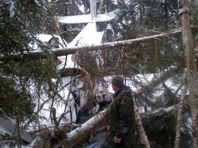
The pilot had decided to climb when a passenger then observed trees. The pilot pulled up to avoid them, but the airplane struck trees and terrain, sustaining substantial damage to the fuselage, wings, and empennage.
Radar data revealed that the pilot had never become established on the approach, at no point was in position to land, and was never closer than 1 mile northeast of the airport before flying into rising terrain. No anomalies with airport lighting were discovered. Examination of the GPS-A approach procedure revealed that it was not authorized for use at night. Weather data recorded near the time of the accident indicate visibility below VFR minimums at 2.5 miles in light snow and mist and a 1,400-foot overcast ceiling, which was also below the published minimum descent altitude.
The National Transportation Safety Board determines the probable cause(s) of this accident to be:
The pilot's improper in-flight planning and decision making, which resulted in attempted visual flight in night instrument meteorological conditions and subsequent impact with terrain.
(New York State Department of Environmental Conservation photo)
 Unfortunate... ANN/SportPlane Resource Guide Adds To Cautionary Advisories

