Will Lay A Baseline For The Global Precipitation Measurement Core Observatory
Rain, ice, hail, severe winds, thunderstorms, and heavy fog – the Appalachian Mountains in the southeast United States have it all. On May 1, NASA begins a campaign in western North Carolina to better understand the difficult-to-predict weather patterns of mountain regions. The field campaign serves as ground truth for measurements made by the Global Precipitation Measurement (GPM) mission's Core Observatory.
GPM is an international satellite mission to observe rain and snow around the world. The advanced instruments on the GPM Core Observatory satellite, launched Feb. 27, provide the next generation of precipitation measurements, including the new capability to detect snow and light rain.
"What we're trying to do is study and learn about the precipitation from the summit to sea, how it evolves as it moves from the mountains to the plains," said Walt Petersen of NASA's Wallops Flight Facility in Virginia, who is leading the field campaign. "Then we use that information to improve satellite observations of precipitation and how those observations can best be used in applications like hydrologic models."
Hydrologic models are used by water managers to predict where rainwater goes after it hits the ground – underground and into streams and rivers where it supplies freshwater to the region, or becomes a natural hazard. Evaluating and improving these models is an important part of the field campaign.
"This is a region that is always under some sort of threat," said precipitation scientist Ana Barros of Duke University in Durham, N.C., who is hosting the field campaign. She's been working with local authorities in the Upper Tennessee, Catawba-Santee, Yadkin-Pee Dee and Savannah River basins, who are very interested in the outcome, to set up the rain-monitoring network for the campaign. "They have landslides, they have flash floods, they have very severe windstorms, they have lots of hail storms in the summer time, they also get hurricanes and tropical storms. So they really value and appreciate the data because they feel they can make good use of it."
Mountain precipitation is difficult to measure, even from satellites. The shape of the rugged slopes interacts with and produces a wide variety of rainfall, through poorly understood processes specific to mountains, said Barros. On the ground, rain gauges have to be set up and maintained in remote areas only accessible by foot or on horseback, and ridges block weather radars from seeing very far into the mountains.
Nevertheless, the Integrated Precipitation and Hydrology Experiment field campaign, running from May 1 to June 15, 2014, combines intense ground coverage with airborne sensors flying through and above rain clouds. When a storm moves in, they’ll snap pictures of precipitation from the top of the clouds to the bottom of valleys.
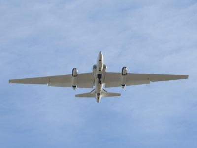
Satellite overpasses from the Tropical Rainfall Measuring Mission and the GPM Core Observatory provide the view from space. In case satellites aren't overhead during a storm, NASA's ER-2 high altitude research plane flying at 65,000 feet and managed by the agency's Armstrong Flight Research Canter in Edwards, Calif., carries several sensors including two that simulate measurements made by the GPM Core Observatory. At 10,000 to 25,000 feet, the University of North Dakota's Citation aircraft flies through clouds to measure raindrops and ice particles where they form.
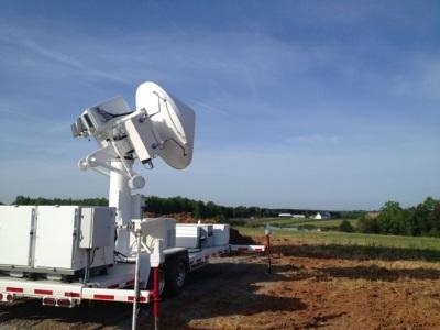
Multiple weather radars – including the NASA's transportable Polarimetric Radar and Dual-Frequency, Dual-Polarimetric Doppler Radar, as well as a NOAA polarimetric radar – measure rain as it forms in clouds and falls to the ground. Then, researchers from Duke University, NOAA's Hydrometeorological Test Bed, NASA, and others have set up a dense network of rain gauges and other equipment to measure fallen precipitation at ground level. Additional sensors to detect soil moisture underground and stream height then follow the water as it flows downstream from the mountains to the plains.
"That's our dream scenario," Petersen said. "We'll learn something more about how and where rainwater is actually made in the clouds, how much of it falls out of the cloud to the ground, and then what happens to the rainfall when it gets into our hydrologic network."
If the weather cooperates, the science team expects to end the six-week campaign with detailed and scientifically robust data to improve their understanding of both the fundamental science of mountain rainfall and how to best estimate rainfall using satellite observations over these remote and rugged regions.
"In a way remote sensing is the only hope to observe the hydrologic cycle over mountains," said Barros. "The potential to do this from space is great and resolves a great problem because we can look at the larger area without having to deal with these obstacles."
(NASA Images. Top: NASA's Dual-frequency, Dual-polarization, Doppler Radar (D3R) is one of several ground radars measuring rain as it falls from clouds. It has the same two frequencies as are on the GPM Core Observatory Satellite. Bottom: NASA's high-altitude ER-2 aircraft carries three radars and a radiometer to measure rainfall from 65,000 feet)
 ANN's Daily Aero-Term (04.28.24): Airport Marking Aids

