Wed, Mar 04, 2015
Eight Major Metro Areas, Gulf Of Mexico Included In First Release
Garmin is rolling out a new version of Garmin Pilot for iOS, which adds a suite of features tailored to helicopter operators. These features incorporate helicopter route charts throughout eight U.S. metropolitan areas, including the Gulf of Mexico. Additionally, the latest version of Garmin Pilot allows pilots to easily identify and document the highest obstacle along their flight plan route, which fulfills Part 135 Helicopter Emergency Medical Service (HEMS) requirements set forth by the FAA.
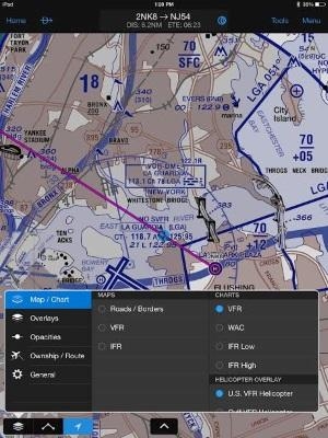
Helicopter Route Charts within Garmin Pilot provide detailed information applicable to the unique operations carried out by these operators. These three-color charts depict helicopter airways and routes, heliports with associated frequency and lighting capabilities, NAVAID information and obstructions. Additionally, pictorial symbols, roads and geographical features are notated on these charts for easier identification in urban areas with high concentrations of helicopter activity.
Garmin Pilot includes VFR and IFR Helicopter Route Charts for eight major metropolitan areas, including:
- Baltimore
- Boston
- Chicago
- Dallas-Ft.Worth
- Detroit
- Houston
- Los Angeles
- New York
Coverage for the Gulf of Mexico is also available, which includes offshore oil drilling platforms and more.

For helicopter air ambulance operators, rules recently established by the FAA requiring pilots to identify and document the highest obstacle along a planned route (§ 135.615), can now fulfill those requirements within Garmin Pilot. When entering a departure and destination airport pair, Garmin Pilot conveniently identifies the highest obstacle along the route of flight in mean sea level (MSL) and above ground level (AGL) within the Flight Plan page and notates the obstacle graphically on the moving map page.
The latest version of Garmin Pilot for iOS is available immediately as a free update, providing operators access to additional chart information tailored to helicopter operators and the opportunity to conveniently meet HEMS requirements.
(Images provided by Garmin)
FMI: www.garmin.com
More News
Aero Linx: Model Aeronautical Association of Australia MAAA clubs are about fun flying, camaraderie and community. For over 75 years, the MAAA has been Australia’s largest fl>[...]
Touchdown Zone Lighting Two rows of transverse light bars located symmetrically about the runway centerline normally at 100 foot intervals. The basic system extends 3,000 feet alon>[...]
“Discovery and innovation are central to our mission at Virgin Galactic. We’re excited to build on our successful record of facilitating scientific experiments in subor>[...]
How To Get A Story On Aero-TV News/Feature Programming How do I submit a story idea or lead to Aero-TV? If you would like to submit a story idea or lead, please contact Jim Campbel>[...]
Student Pilot Reported That During Rotation, “All Of A Sudden The Back Of The Plane Kicked To The Right..." Analysis: The student pilot reported that during rotation, “>[...]
 ANN's Daily Aero-Linx (05.02.24)

