North Dakota TFR: 08/06/04 | Aero-News Network
Aero-News Network
RSS icon RSS feed
podcast icon MP3 podcast
Subscribe Aero-News e-mail Newsletter Subscribe

Airborne Unlimited -- Most Recent Daily Episodes

Episode Date

Airborne-Monday

Airborne-Tuesday

Airborne-Wednesday Airborne-Thursday

Airborne-Friday

Airborne On YouTube

Airborne-Unlimited-04.22.24

Airborne-Unlimited-04.16.24

Airborne-FlightTraining-04.17.24 Airborne-AffordableFlyers-04.18.24

Airborne-Unlimited-04.19.24

Join Us At 0900ET, Friday, 4/10, for the LIVE Morning Brief.
Watch It LIVE at
www.airborne-live.net

Fri, Aug 06, 2004

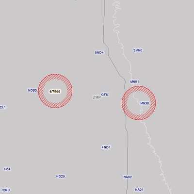
North Dakota TFR: 08/06/04

NOTAM Number: FDC 4/7966
Location: Grand Forks, North Dakota
Beginning Date: August 06, 2004 at 16:00 UTC (August 06, 2004 at 11:00 CDT)
Ending Date: August 06, 2004 at 19:55 UTC (August 06, 2004 at 14:55 CDT)
Reason for NOTAM: Temporary flight restrictions for national security
Type: VIP
Replaced NOTAM(s): n/a
FAA Contact(Pilots):
No Pilots May Operate An Aircraft in the Areas Covered by this Notam Except as Described.


Affected Area(s)
 
Area A
 Airspace Definition:
 Circle Center: 9 nautical miles from GRAND FORKS VOR_DME(GFK) on the 264 radial (Latitude: 47�57'39"N, Longitude: 97�24'3"W)
 Radius: 3 nautical miles
 Altitude: From and including the surface up to 3000 feet
 Operating Restrictions and Requirements:
 Effective Date: August 06, 2004 at 16:00 UTC (August 06, 2004 at 11:00 CDT) - August 06, 2004 at 16:50 UTC (August 06, 2004 at 11:50 CDT)
 
Area B
 Airspace Definition:
 Circle Center: 6 nautical miles from GRAND FORKS VOR_DME(GFK) on the 95 radial (Latitude: 47�55'44"N, Longitude: 97�1'51"W)
 Radius: 3 nautical miles
 Altitude: From and including the surface up to 3000 feet
 Operating Restrictions and Requirements:
 Effective Date: August 06, 2004 at 16:35 UTC (August 06, 2004 at 11:35 CDT) - August 06, 2004 at 18:25 UTC (August 06, 2004 at 13:25 CDT)
 
Area C
 Airspace Definition:
 Circle Center: 8 nautical miles from GRAND FORKS VOR_DME(GFK) on the 264 radial (Latitude: 47�57'39"N, Longitude: 97�24'3"W)
 Radius: 3 nautical miles
 Altitude: From and including the surface up to 3000 feet
 Operating Restrictions and Requirements:
 Effective Date: August 06, 2004 at 18:05 UTC (August 06, 2004 at 13:05 CDT) - August 06, 2004 at 19:55 UTC (August 06, 2004 at 14:55 CDT)
 
Other Information:
ARTCC: ZMP
IssueDate: August 05, 2004 at 13:34 UTC (August 05, 2004 at 8:34 CDT)
Authority: Title 14 CFR section 91.141

FMI: http://tfr.faa.gov/tfr/jsp/list.jsp

Advertisement

More News

ANN's Daily Aero-Term (04.26.24): DETRESFA (Distress Phrase)

DETRESFA (Distress Phrase) The code word used to designate an emergency phase wherein there is reasonable certainty that an aircraft and its occupants are threatened by grave and i>[...]

ANN's Daily Aero-Linx (04.26.24)

Aero Linx: The International Association of Missionary Aviation (IAMA) The International Association of Missionary Aviation (IAMA) is comprised of Mission organizations, flight sch>[...]

Airborne 04.22.24: Rotor X Worsens, Airport Fees 4 FNB?, USMC Drone Pilot

Also: EP Systems' Battery, Boeing SAF, Repeat TBM 960 Order, Japan Coast Guard H225 Buy Despite nearly 100 complaints totaling millions of dollars of potential fraud, combined with>[...]

Airborne 04.24.24: INTEGRAL E, Elixir USA, M700 RVSM

Also: Viasat-uAvionix, UL94 Fuel Investigation, AF Materiel Command, NTSB Safety Alert Norges Luftsportforbund chose Aura Aero's little 2-seater in electric trim for their next gli>[...]

Airborne-NextGen 04.23.24: UAVOS UVH 170, magni650 Engine, World eVTOL Directory

Also: Moya Delivery Drone, USMC Drone Pilot, Inversion RAY Reentry Vehicle, RapidFlight UAVOS has recently achieved a significant milestone in public safety and emergency services >[...]

blog comments powered by Disqus


Advertisement

Advertisement

Podcasts

Advertisement

© 2007 - 2024 Web Development & Design by Pauli Systems, LC